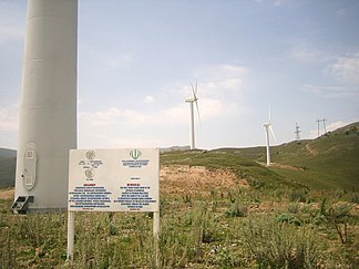
Bazum Mountains
| Bazum Mountains | ||
|---|---|---|
|
Wind turbines at the Pushkin Pass |
||
| Highest peak | Chalab ( 3016 m ) | |
| location | Lori , Shirak , Tavush ( Armenia ) | |
| part of | Lesser Caucasus | |
|
|
||
| Coordinates | 40 ° 54 ' N , 44 ° 27' E | |
The Bazum Mountains ( Armenian Բազումի լեռնաշխթա ; Russian Базумский хребет ) is a mountain range in the central section of the Lesser Caucasus .
The Bazum Mountains extend over a length of approximately 70 km in a west-east direction north of the upper Pambak valley. The valley of the Dsoraget runs north . The Pambak River cuts through the eastern part of the Bazum Mountains in a northerly direction. Even further east is the highest mountain in the mountain range, the Chalab , with a maximum height of 3,016 m . In the far west is the somewhat lower Urasar ( 2992 m ). The M3 trunk road runs over the middle section of the ridge near Bazum . The road runs through the Stepanavan tunnel under the Pushkin Pass , which is 2037 m high .
The mountain range consists mainly of sedimentary rocks of volcanic origin and intrusions of granite . The mountain slopes are mostly covered by forest steppe . Subalpine and alpine vegetation grows in the summit locations . There is deciduous deciduous forest in the Pambak Gorge .
Mountains (selection)
Below are a number of peaks along the main ridge of the Bazum Mountains, sorted from west to east:
![]() Map with all coordinates: OSM | WikiMap
Map with all coordinates: OSM | WikiMap
Web links
Individual evidence
- ↑ a b c Article Bazum Mountains in the Great Soviet Encyclopedia (BSE) , 3rd edition 1969–1978 (Russian)

