Dsoraget
|
Dsoraget Ձորագետ |
||
|
Course of the Dsoraget in Armenia (in the light green area) |
||
| Data | ||
| location | Lori ( Armenia ) | |
| River system | Kura | |
| Drain over | Debed → Chrami → Kura → Caspian Sea | |
| source | in the Bazum Mountains 40 ° 59 ′ 46 ″ N , 44 ° 1 ′ 4 ″ E |
|
| Source height | approx. 2200 m | |
| Association with |
Pambak zum Debed Coordinates: 40 ° 57 ′ 25 " N , 44 ° 37 ′ 57" E 40 ° 57 ′ 25 " N , 44 ° 37 ′ 57" E |
|
| Mouth height | 920 m | |
| Height difference | approx. 1280 m | |
| Bottom slope | approx. 19 ‰ | |
| length | 67 km | |
| Catchment area | 1460 km² | |
| Drain |
MQ |
42.9 m³ / s |
| Small towns | Stepanawan | |
|
The Dsoraget in its valley, photographed from the bridge in Stepanawan |
||
The Dsoraget ( Armenian Ձորագետ ) is a river in the Lori Province in northern Armenia .
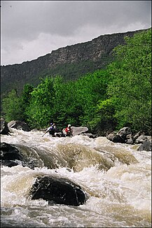
It rises around 2200 m above sea level in the Bazum Mountains , flows in the area around Stepanawan through gorges up to 200 meters deep and joins the Pambak zum Debed , a tributary of the Kura , after 67 kilometers near the village of Dzoragjugh, coming from the right . The Dsoraget is used as a kayak water .
Web links
Commons : Dsoraget - collection of images, videos and audio files


