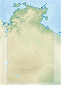
Beagle Gulf
| Beagle Gulf | ||
|---|---|---|
| Waters | Timor Sea | |
| Land mass | Australia (continent) , Bathurst Island | |
| Geographical location | 12 ° 10 ′ S , 130 ° 29 ′ E | |
|
|
||
| width | approx. 50 km | |
| depth | approx. 100 km | |
| Islands | Dum In Mirrie Island , Beer Eetaar Island , Windirr Island , Gros Island ( Butlyerahit Island ), Quail Island | |
|
HMS Beagle |
||
The Beagle Gulf (German Beagle Golf ) is the body of water on which Darwin , the capital of the Australian Northern Territory , lies. In the west it flows into the Timor Sea and in the east the Clarence Strait connects it with the Van Diemen Gulf . Bathurst Island limits it to the north. It is about 100 km long and 50 km wide. It surrounds the Quail Island Group . On the south coast of the bay are the ria-like bays Port Darwin (with the city of Darwin) and Bynoe Harbor .
Surname
The Gulf was named after the ship HMS Beagle , on which Charles Darwin and Robert Fitzroy sailed around parts of Australia. The Cambridge Dictionary of Australian Places incorrectly states that “he was named after his ship in 1836 by Robert Fitzroy, commander of HMS Beagle. The Beagle mapped this area with Charles Darwin as a naturalist on board. ”However, Darwin and Fitzroy sailed in 1836 from King George Sound ( Western Australia ) directly to the Cocos Islands on the south coast of Java and from there via Cape Town back to England . They stayed about 3,000 nautical miles from the Beagle Gulf and could not have known of its existence.
Individual evidence
- ^ Cambridge Dictionary of Australian Places.
- ^ Alan Powell: Who Named Beagle Gulf ?: A Cautionary Tale . Journal of Northern Territory History, No. 22, 2011: 104-108. ISSN 1034-7488 . Accessed October 29, 2012.

