Belle Fourche River
| Belle Fourche River | ||
|
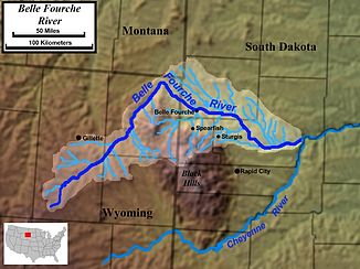
Course and catchment area of the Belle Fourche River |
||
| Data | ||
| Water code | US : 1265120 | |
| location | Wyoming , South Dakota | |
| River system | Mississippi River | |
| Drain over | Cheyenne River → Missouri River → Mississippi River → Gulf of Mexico | |
| source | in south Campbell County 43 ° 39 ′ 7 " N , 105 ° 47 ′ 38" W. |
|
| muzzle | in the Cheyenne River coordinates: 44 ° 26 ′ 5 " N , 102 ° 18 ′ 12" W 44 ° 26 ′ 5 " N , 102 ° 18 ′ 12" W |
|
| Mouth height |
619 m
|
|
| length | 470 km | |
|
View of the upper reaches of the Belle Fourche River in Devils Tower National Monument |
||
The Belle Fourche River is a left tributary of the Cheyenne River . It has a length of 470 km and runs in the US states of Wyoming and South Dakota . It belongs to the catchment area of the Mississippi River .
The Belle Fourche River has its origin in northeast Wyoming, in southern Campbell County , about 15 miles north of Wright . It flows northeast past Moorcroft and Devils Tower .
Near the state line with Montana , it turns abruptly southeast and flows past Belle Fourche and the north side of the Black Hills in western South Dakota . In southern Meade County near Hereford it changes direction to east-northeast and flows into the Cheyenne River about 80 km east-northeast of Rapid City .
The Belle Fourche River leaves the state of Wyoming at its deepest point at an altitude of 945 m. ü. M. This is also the second highest point, which represents the lowest point of a US state.
The river is used for various leisure activities. Some of its water is also used for irrigation in agriculture in western South Dakota. The irrigation area is about 230 km².

