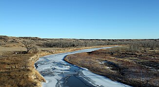
Cheyenne River
| Cheyenne River | ||
|
Cheyenne River catchment area |
||
| Data | ||
| Water code | US : 1267017 | |
| location | Wyoming , South Dakota (USA) | |
| River system | Mississippi River | |
| Drain over | Missouri River → Mississippi River → Gulf of Mexico | |
| source | The confluence of Antelope Creek and Dry Fork Creek in eastern Wyoming 43 ° 25 ′ 34 ″ N , 105 ° 3 ′ 32 ″ W |
|
| muzzle | in the Missouri River dammed up to Lake Oahe coordinates: 44 ° 46 ′ 15 " N , 100 ° 43 ′ 4" W 44 ° 46 ′ 15 " N , 100 ° 43 ′ 4" W |
|
| Mouth height |
480 m
|
|
| length | 475 km | |
| Catchment area | 62,800 km² | |
| Left tributaries | Rapid Creek , Belle Fourche River | |
| Reservoirs flowed through | Angostura Reservoir | |
|
View of the Cheyenne River from I-90 |
||
The Cheyenne River is a right tributary of the Missouri River in Wyoming and South Dakota in the United States. It is approximately 475 km long.
It rises in northeast Wyoming, more precisely in the Thunder Basin National Grassland in northeast Converse County . It then flows eastward to South Dakota, past Edgemont , flows around the southern end of the Black Hills and crosses the reservoir Angostura Reservoir , which was created by the Angostura dam .
On the east side of the Black Hills it flows northeast, past Oral , the Buffalo Gap National Grassland and along the northwest border of the Pine Ridge Reservation and Badlands National Park . The Rapid Creek flows like the Belle Fourche River in the east of Meade County . It then flows northeast along the southern border of the Cheyenne River Reservation . At Cherry Creek which flows Cherry Creek in Cheyenne. It finally flows into the Missouri in Lake Oahe, 50 km northwest of Pierre .

