Angostura dam (USA)
| Angostura dam | |||||||||
|---|---|---|---|---|---|---|---|---|---|
|
|||||||||
|
|
|||||||||
| Coordinates | 43 ° 20 ′ 34 " N , 103 ° 26 ′ 11" W | ||||||||
| Data on the structure | |||||||||
| Construction time: | 1946 to 1949 | ||||||||
| Height above foundation level : | 59 m | ||||||||
| Height of the structure crown: | 975 m | ||||||||
| Crown length: | 619 m | ||||||||
| Crown width: | 3 m | ||||||||
| Base width: | 70 m | ||||||||
| Data on the reservoir | |||||||||
| Altitude (at congestion destination ) | 971 m | ||||||||
| Storage space | 171.16 million m³ | ||||||||
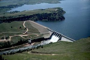
The dam Angostura ( English Angostura Dam ) is a dam in Fall River County , State of South Dakota , USA . It dams the Cheyenne River to a reservoir ( Angostura Reservoir ). The dam is located approximately 14.5 km (9 miles ) southeast of the small town of Hot Springs .
The Angostura Dam was planned and constructed as part of the Pick-Sloan Missouri Basin Program . Construction began on August 23, 1946. It was completed on December 7, 1949. The dam is used for irrigation and flood protection . It is owned and operated by the United States Bureau of Reclamation (USBR) and is also operated by the USBR.
Barrier structure
The barrier structure consists of a gravity dam made of concrete on the left side , which extends from the left bank of the river to the middle and then an embankment dam on the right side, which extends to the right bank of the river.
The height of the barrier structure is 59 m (193 ft ) above the foundation level . The dam crest is at an altitude of 975 m (3,199 ft) above sea level . The total length of the structure crown is 619 m (2030 ft); 295 m (970 ft) of this is due to the dam. The width of the dam is 70 m (230 ft) at the base and 3 m (10 ft) at the crown. The volume of the structure is 649,870 m³ (850,000 cubic yards ).
The dam has both a flood relief and a bottom outlet . A maximum of 6994 m³ / s (247,000 cft / s) can be discharged via the flood discharge, and a maximum of 16.7 m³ / s (590 cft / s) via the bottom outlet.
Reservoir
At the normal storage target of 971 m (3,187 ft), the reservoir extended in 1949 over an area of around 19.6 km² (4841 acres ) and contained 197.26 million m³ (159,919 acre feet ) of water. By 1979 the surface had decreased to 18.66 km² (4612 acres) as a result of sedimentation ; storage space decreased to 161.3 million m³ (130,768 acre-feet) in the same period. USBR gives the storage space for the above traffic jam destination as 171.16 million m³ (138,761 acre-feet).
The reservoir extends over a length of around 27 km (17 miles).
See also
Web links
Individual evidence
- ^ Angostura Division. United States Bureau of Reclamation (USBR), accessed December 30, 2018 .
- ↑ a b c d Angostura Dam. USBR, accessed December 30, 2018 .
- ↑ a b Angostura Reservoir 1979 Sedimentation Survey. (PDF) USBR, p. 9 (Introduction) , accessed on December 30, 2018 (English).

