Beaver (Möhne)
| beaver | ||
|
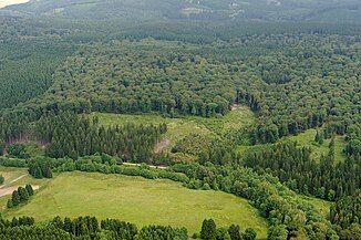
The valley of the beavers in the Rüthen urban forest |
||
| Data | ||
| Water code | DE : 276218 | |
| location | North Rhine-Westphalia , Germany | |
| River system | Rhine | |
| Drain over | Möhne → Ruhr → Rhine → North Sea | |
| source | near the Kleiner Fahrenberg in the Arnsberg Forest 51 ° 26 ′ 22 ″ N , 8 ° 31 ′ 34 ″ E |
|
| Source height | approx. 428 m above sea level NN | |
| muzzle | near Rüthen in the Möhne coordinates: 51 ° 29 '6 " N , 8 ° 26' 53" E 51 ° 29 '6 " N , 8 ° 26' 53" E |
|
| Mouth height | approx. 292 m above sea level NN | |
| Height difference | approx. 136 m | |
| Bottom slope | approx. 17 ‰ | |
| length | 8.1 km | |
| Catchment area | 10.9 km² | |
| Left tributaries | Bärensiepen, Stallsiepen, Öhningsiepen, Kruhbergssiepen | |
| Right tributaries | Flower corner | |
The Biber is an 8.1 km long orographic left or southern tributary of the Möhne in the Arnsberger Wald nature reserve , North Rhine-Westphalia ( Germany ).
course
The beaver rises in the eastern part of the Arnsberg Forest, about 1.4 km north of Brilon- Sharfenberg. Its source is south of the Kleiner Fahrenberg at about 428 m above sea level. NN . From here the stream flows in a north-westerly direction through the Arnsberg Forest. After its water has flowed through the small beaver pond, the beaver flows out at Rüthen at around 292 m above sea level. NN in the Ruhr tributary Möhne .
Hydrology and catchment area
The beaver overcomes a height difference of 137 m on its 8.1 km long path, which corresponds to a mean bed slope of 16.9 ‰. It drains a 10.9 km² catchment area via the Möhne, Ruhr and Rhine to the North Sea .
Individual evidence
- ↑ a b German basic map 1: 5,000
- ↑ a b Topographical Information Management, Cologne District Government, Department GEObasis NRW
