Bill stones
|
Bill stones
|
||
|
Natural monument "Billersteine" (2020) |
||
| location | Mühltal , Darmstadt-Dieburg district , Hesse | |
| surface | approx. 854 m² | |
| Geographical location | 49 ° 48 ' N , 8 ° 42' E | |
|
|
||
| Setup date | May 10, 1938 | |
The Billersteine are an extensive geological natural monument in the Waschenbach district , Mühltal municipality , in the Darmstadt-Dieburg district in southern Hesse.
location
The Billersteine are located in the natural area of the Vorderer Odenwald , Lower Modautal (Mühltal). The natural monument is located south-southwest of Waschenbach and west of the county road 138 to Frankenhausen . It covers an area of approximately 854 square meters. To the west lies the quarry of Nieder-Beerbach , east of the quarry of Waschenbach.
description
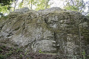
The Billersteins are a rock face made of gabbro . They are a remnant of a former smaller quarry that was used from around 1880 to 1911. The Billersteins were listed as a natural monument before 1932. Today they stand by decree of May 4, 1938 published in the Gazette of the Hessian state government no. 72 of 10 May 1938 under conservation . The rock face is in the middle of the forest, with some large beech trees growing in front of it . The rocks are overgrown with moss in places.
Impairments
The Billersteins are used as climbing rocks. Although the installation of new safety devices is prohibited in the natural monument, new climbing routes were drilled in 2019. In addition, paths to the rock were laid out and signs were put up. The owner Hessen , represented by Hessen-Forst , threatened to block the rock for climbing. The changes had to be removed again.
See also
Individual evidence
- ↑ Otto Klausing: Geographical land survey: The natural space units on sheet 151 Darmstadt. Federal Institute for Regional Studies, Bad Godesberg 1967. → Online map (PDF; 4.3 MB)
- ^ "Environmental protection" map. BürgerGIS district of Darmstadt-Dieburg. Darmstadt-Dieburg district, accessed on August 17, 2020 .
- ↑ Map of the natural monument with surroundings. natureg.hessen.de, accessed on August 17, 2020 .
- ^ A b Horst Bathon, Georg Wittenberger: The natural monuments of the Darmstadt-Dieburg district with biotope tours , 2nd expanded and completely revised edition. In: Schriftenreihe Landkreis Darmstadt-Dieburg, (Ed.) District Committee of the District of Darmstadt-Dieburg - Lower Nature Conservation Authority, Darmstadt, 2016. ISBN 978-3-00-050136-4 . 243 pages. Pp. 88-89.
- ↑ Heinz Schuchmann: The hard stone works Thomas in Waschenbach. October 12, 2012, accessed August 17, 2020 .
- ↑ Ordinance on safeguarding natural monuments in the Darmstadt district. (pdf; 26 kB) Darmstadt District Office, May 4, 1938, accessed on August 17, 2020 .
- ↑ Tours drilled illegally! AG Climbing & Nature Conservation in the Odenwald eV, 2019, accessed on August 17, 2020 .

