
Blauwbrug
Coordinates: 52 ° 21 ′ 59 ″ N , 4 ° 54 ′ 3 ″ E
| Blauwbrug | ||
|---|---|---|
 |
||
| use | Road bridge , tram | |
| Convicted | Amstelstraat, trams 9, 14 | |
| Subjugated | Amstel | |
| place | Amsterdam | |
| Building number | 236 | |
| construction | Plate bridge | |
| width | 18.6 m | |
| Longest span | 14 m | |
| completion | 1883 | |
| planner | Bastiaan de Greef, Willem Springer |
|
| location | ||
|
||

The Blauwbrug ( German Blue Bridge ) is a bridge over the Amstel River in Amsterdam . It connects the Amstelstraat coming from the west with the Waterlooplein . The third bridge at this point owes its name to a previous building, the wooden parts of which were painted blue.
history
The building was designed by the Dutch architects Bastiaan de Greef and Willem Springer in the style of eclecticism . The lavishly designed Seine bridges in Paris were the model . The city architects at the time planned this and the Hogesluis bridge, which was built at the same time, on behalf of the city planning office Publieke Werken on the occasion of the International Colonial Exhibition in 1883 . Half of the construction costs of the Blauwbrug were taken over by the Amsterdam Omnibus Company.
In Yiddish the bridge is called Bloubrik . The building that leads to the former Jewish quarter around the Waterlooplein appears in some Jewish proverbs.
The lanterns are decorated with the Austrian imperial crown.
During the transfer of the throne to Queen Beatrix on April 30, 1980, street fighting broke out on the bridge between demonstrators and the mobile unit of the Dutch police. The 1983 novel The Battle of the Blue Bridge (Dutch De slag om de Blauwbrug ) by Adrianus Franciscus Theodorus van der Heijden is based on this event .
Picture gallery

Blaubrug and Amstel, photograph (around 1895)

Blouwbrug im Schnee , painting (1991) by Frans Koppelaar
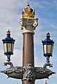
Lantern on the Blauwbrug

Detail of the bridge railing

Detail of the crown


_bridge_ornament.jpg)
