
Blidinjsko jezero
| Blidinjsko jezero ("Blidinje Lake") | ||
|---|---|---|
_z_Maleho_Vranu.jpg)
|
||
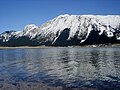
| View of Lake Blidinje from the Mali Vran peak | ||
| Geographical location | Bosnia and Herzegovina | |
| Data | ||
| Coordinates | 43 ° 36 '29 " N , 17 ° 29' 37" E | |
|
||
| Altitude above sea level | 1173 m | |
| surface | 3.2 km² | |
| length | 2.5 km | |
| width | 2.1 km | |
| Maximum depth | 4.5 m | |

The Blidinjsko jezero ("Blidinje Lake") is the largest mountain lake in the state of Bosnia and Herzegovina . Adjacent union communities are Posušje and Tomislavgrad .
The lake is located in Herzegovina , at the end of the Dugo polje valley between the mountains Čvrsnica , Vran and Muharnica . It lies at an altitude of 1173 m and is 2.1 km long and 2.5 km wide.
The lake has been a nature park since April 30, 1995 . These include Vran, Čvrsnica, the Masna luka forest reserve and the Grabovica gorge .
Others
- In the vicinity of the lake there are over 200 medieval tombstones, so-called stećci (singular: stećak ).
- In the nature park near the lake, you can see the cave of Mijat Tomić , a Croatian heathen and folk hero who is said to have hid there from the Ottomans in the 17th century .
gallery

Burial ground with stećci

Traditional farmhouse

Winter sports on the lake

Motel in Risovac
In the spring

Weekend houses


Web links
Commons : Blidinjsko jezero - collection of pictures, videos and audio files
- http://www.bhtourism.ba/ger/blidinjenp.wbsp (available in German and English)