Blomstrandhalvøya
| Blomstrandhalvøya | ||
|---|---|---|
| Waters | Kongsfjord , Greenland Sea | |
| Archipelago | Spitsbergen | |
| Geographical location | 78 ° 58 '40 " N , 12 ° 4' 38" E | |
|
|
||
| length | 5 km | |
| width | 4 km | |
| surface | 16 km² | |
| Highest elevation | Irgensfjellet 385 moh. |
|
| Residents | uninhabited | |
| main place | Ny-London (historical) | |
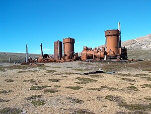
| Steam engine in Ny London | ||
Blomstrandhalvøya ("Flower Beach Peninsula") is an uninhabited island in the Svalbard Archipelago belonging to Norway .
geography
Blomstrandhalvøya is located across from Ny-Ålesund in the Kongsfjord south of the edge of the Blomstrandbreen glacier , which used to reach the island. That is why - as the current name still suggests - it was mistaken for a peninsula . The island is about five kilometers long and up to four kilometers wide. Their area is 16 km².
The island is mountainous and reaches its greatest heights in the peaks Irgensfjellet (385 m) and Bratliekollen (370 m). The Blomstrandsalen saddle stretches between the two . At lower altitudes in the north-east and south there are several smaller lakes and streams and near the Jakobskjelda spring a waterfall with a height of 5.3 m. There are several caves and sinkholes in the small bay of Grottevika on the west coast . This is also where the grottos beacon is located with a fire height of ten meters.
Blomstrandhalvøya consists mainly of crystalline limestone .
history
In 1906 marble was discovered on Blomstrandhalvøya . Five years later, the English businessman Ernest Mansfield (1862–1924) opened his Northern Exploration Company Ltd. founded a quarry and founded the mining settlement of London on Peirsonhamna Bay on the south coast of the (pen) island. Heavy machinery and cranes were purchased and workshops, warehouses and houses for 70 people were built. Business did not go well because the marble turned out to be of inferior quality. After the dismantling had stopped anyway during the First World War , operations were completely stopped in 1920. Remnants of the machines and some houses have been preserved to this day and are under monument protection.
Web links
- Kristin Prestvold: London (Peirsonhamna) , Cruise Handbook of Svalbard, Norsk Polarinstitutt (English)
Individual evidence
- ^ The Norwegian Pilot . Volume 7: Sailing Directions Svalbard and Jan Mayen (PDF; 55.0 MB), The Norwegian Hydrographic Service and Norwegian Polar Institute, 3rd edition, Stavanger 2012 (PDF version 3.5, May 2016), ISBN 978-82-90- 65330-4 , p. 43 (English).
- ↑ Jakobskjelda . In: The Place Names of Svalbard (first edition 1942). Norsk Polarinstitutt , Oslo 2001, ISBN 82-90307-82-9 (English, Norwegian).
- ↑ Grottevika . In: The Place Names of Svalbard (first edition 1942). Norsk Polarinstitutt , Oslo 2001, ISBN 82-90307-82-9 (English, Norwegian).
- ↑ Fyrliste for Svalbard (PDF; 20 kB), accessed on August 11, 2016 (Norwegian).
- ↑ Blomstrandhalvøya . In: The Place Names of Svalbard (first edition 1942). Norsk Polarinstitutt , Oslo 2001, ISBN 82-90307-82-9 (English, Norwegian).
- ↑ Kristin Prestvold: London (Peirsonhamna) , Cruise Handbook of Svalbard, Norsk Polarinstitutt (English)


