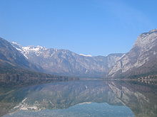
Bohinjsko jezero
| Bohinjsko jezero | ||
|---|---|---|

|
||
| General view from the mountain birds of | ||
| Geographical location | Slovenia | |
| Tributaries | Savica | |
| Drain | Week of a Save → Save | |
| Data | ||
| Coordinates | 46 ° 17 '2 " N , 13 ° 52' 2" E | |
|
|
||
| Altitude above sea level | 525 m. i. J. | |
| surface | 3.18 km² | |
| length | 4.1 km | |
| width | 1.2 km | |
| Maximum depth | 45 m | |
The Bohinjsko jezero ( German : Wocheiner See , sometimes also Bohinjsee ) is a lake with an area of 3.18 km² in northwestern Slovenia . It lies at an altitude of 525 m. i. J. in the municipality of Bohinj ( Wochein ) and is part of the Triglav National Park . The lake is approx. 4100 meters long, approx. 1200 meters wide and up to 45 meters deep.
The main tributary is the Velika Savica ( Great Savica ) river, which rises in the nearby Savica waterfall (Slovenian: Slap Savice ). It unites with the Mala Savica ( Little Savica ) to the Savica, which flows into the lake. The outflow of the lake is the Sava Bohinjka ( Wocheiner Save ), which joins the Sava Dolinka at Radovljica ( Radmannsdorf ) to form the Save (Slovene Sava ).
geography
The name Bohinj / Wochein refers to the Alpine basin in the headwaters of the Wocheiner Sava from the settlement of Soteska upwards. In the upper section there is a closed lake basin. This then forks into two parallel valleys, Zgornja and Spodnja dolina (the upper and lower valley), which are separated by the striking mountain divide of Savnica ( 863 m ) and Rudnica ( 946 m ). In the lower part is the small basin of Nomenj. The entire valley is a good 20 km long and a maximum of 5 km wide.
Geological history
This valley was already formed in the Oligocene , when a sea bay reached from the east to here. During the ice ages, large amounts of ice were pushed down from the surrounding mountains, filling the basin with moraines. The basin of Lake Bohinj formed the frontal hollow of the Wochein Glacier; the frontal moraine can still be seen, especially at the settlement of Stara Fužina. The glacier deposits dammed up the water on the east side and in this way formed the lake. It was once bigger and higher, as evidenced by the higher terraces on the east and south sides.
Limnology
The most important constant surface inflow is the Savica, which rises partly as a waterfall below the Komarča wall in the upper part of the lake basin. The Savica deposits debris in the lake, which forms an ever-growing delta. The lake water is renewed three times a year. 65 species of algae , eight species of molluscs and five species of fish ( lake trout , burbot , whitefish , minnow and arctic char ) live here. During periods of heavy rain, the level of the lake increases by two to three meters. On the rugged slopes, streams with waterfalls appear, which can deposit gravel and rubble in the lake, but recede and disappear a few hours after the rain. In this way, mighty embankments were created, such as Naklova glava east of the Ukanc settlement and Na jami below the Govic waterfall. In winter the lake freezes over almost regularly.
tourism
There are accommodations for tourists in the towns of Ukanc, Ribčev Laz, Stara Fužina ( Althammer ) on Lake Wochein and in Bohinjska Bistrica ( Wocheiner Feistritz ), which is four kilometers (south) east of the lake. Numerous private rooms are available in the villages of the two valleys. The lake can be hiked around in just under three hours. There is only road traffic on the southern shore of the lake between Stara Fužina and Ukanc (campsite).
Lake tour
From Ribčev Laz at the southeast end of the lake to the beginning in the west in Ukanc and back there is an opportunity for excursions with a small electric motor ship.
Sports facilities
The clear lake is particularly suitable for swimming and rowing. Boathouses on the south and north shores of the lake that are easily accessible by car rent out boats, canoes, kayaks and SUPs. Because of the gentle winds, the lake is also suitable for less experienced surfers and sailors. White water rafting is possible on the Sava Bohinjka River, but the rapids in the shorter, narrow part just behind the lake outlet require an experienced boat guide (White Water II).
Mountain bike tours are also recommended, but the rules of the protection zone of the Triglav National Park must be observed . The Jezero and Zlatorog Hotels have indoor swimming pools, and the Zlatorog Hotel also has tennis courts. However, the Hotel Zlatorog has been closed for a number of years, the municipality is hoping for an investor to renovate it and reopen it. On the Vogar-Alm you will find suitable terrain for hang-gliding and paragliding.
There are ski areas on the Kobla above Bohinjska Bistrica and the Vogel above Ukanc. The meadows in and around Bohinj offer good cross-country skiing conditions. The high mountain world above Bohinj is one of the best ski touring areas in the Julian Alps.
Individual evidence
literature
- Karl Baedeker : Slovenia , Verlag Karl Baedeker, ISBN 978-3-8297-1268-2


