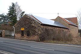
Bolanderhof
|
Bolanderhof
Local church Bolanden
Coordinates: 49 ° 38 ′ 52 ″ N , 8 ° 1 ′ 38 ″ E
|
|
|---|---|
| Height : | 230 m above sea level NN |
| Postal code : | 67292 |
| Area code : | 06352 |
|
Bolanderhof
|
|
The Bolanderhof is a hamlet. Today it is divided between the town of Kirchheimbolanden and the local community of Bolanden .
location
The Bolanderhof is located on Kaiserstraße between Kirchheimbolanden and Marnheim . The border between Kirchheimbolanden and Bolanden runs straight through the settlement, the house numbers are assigned twice in both halves (Kirchheimbolander side: 1 and 2; Bolander side: 1, 2, 4 and 5). The Bolanderhof is surrounded by fields.
history
The Bolanderhof was built on the ruins of the lost Altenbolanden Castle . In 1353 the Bolanderhof consisted of two courtyards; one belonged to the Rothenkirchen monastery , the other to the Hane monastery . In the 15th century there was a dispute between the princes of Nassau ( rule Kirchheim and Stauf ) and the Count Palatinate ( Electoral Palatinate ) over ownership of the Bolanderhof, which was resolved in a border treaty of 1533 by dividing the Bolanderhof. This division continued even when Bolanden fell to Nassau-Weilburg in 1706 and the border through the Bolanderhof no longer represented a rule border.
Infrastructure
The Bolanderhof has a bus stop on Landesstraße 401.
Individual evidence
- ^ Adolph Koellner: History of the rule Kirchheim-Boland and Stauf. Edited from JM Kremer's and J. Andreä's manuscripts, reliable documents and other aids. Edited by the Association for Nassau antiquity and historical research, Wiesbaden 1854, p. 226f
