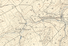
Bornwald houses
The Bornwald houses are a desolate settlement from the 19th century in the Bornwald of the same name, southeast of the Zschopau district of Krumhermersdorf in the Ore Mountains .
location
The area is located about 2 kilometers southeast of Krumhermersdorf on a stream that flows into the Lautenbach.
It can be reached at best on the north running state road 207 Börnichen - federal road 174 and from there continue on foot through forest trails.
history
Around 1800 a certain Kurt Gessler applied to build a water-powered spinning mill in the Bornwald near Richter's mill . Construction finally began around 1820.
At that time, the black pond was created in its current size. In addition, starting from there, a relatively wide canal was laid to Richter's Mühle (also Bornwaldmühle ), the location of the spinning mill.
In 1830 the spinning mill (also Winklermühle ) burned down completely, as the then Krumhermersdorf pastor Höfel noted in a chronicle. The building was later rebuilt and some houses were built in the immediate vicinity. In 1831, Fritsche's cotton mill had 2,778 spindles . On 28 October 1854, the plant burned down again and remained as a ruin desolate lie.
The entire settlement existed until after the construction of the dams Neunzehnhain I in 1907 and Neunzehnhain II in 1914. As a result of the dam construction, the Bornwald became a drinking water protection area. As a result, all houses were completely demolished except for the forest barn that still exists today and the ruins of the spinning mill.
literature
- The middle Zschopau area (= values of our homeland . Volume 28). 1st edition. Akademie Verlag, Berlin 1977, p. 194.
Web links
- Location of the Bornwald houses on the Oberreith map from 1821 and on a colored map from 1875
Individual evidence
- ↑ Chronicle of the Krumhermersdorfer Pastors. In: krumhermersdorf.de. Retrieved February 4, 2011 .
- ^ Albert Schiffner : Handbook of geography, statistics and topography of the Kingdom of Saxony . Friedrich Fleischer, Leipzig 1839, p. 86 ( google.de ).
- ↑ a b Krumhermersdorf 100 years of Bornwald houses. In: krumhermersdorf.de. Retrieved February 4, 2011 .
Coordinates: 50 ° 43 '20.11 " N , 13 ° 7' 50.04" O

