
Borthwick Water
| Borthwick Water | ||
 The Borthwick Water just before the estuary |
||
| Data | ||
| location | Scottish Borders , Scotland | |
| River system | tweed | |
| Drain over | Teviot → Tweed | |
| source | Confluence of several streams in Craik Forest 55 ° 21 ′ 42 ″ N , 3 ° 1 ′ 36 ″ W |
|
| muzzle | at Hawick in the Teviot coordinates: 55 ° 24 '36 " N , 2 ° 49' 37" W 55 ° 24 '36 " N , 2 ° 49' 37" W.
|
|
| length | 26 km | |
The Borthwick Water is a river in the Scottish Borders Scottish Council Area .
course
The river is created by the confluence of Craikhope Burn , Howpasley Burn and Brownshope Burn on the eastern edge of Craik Forest . Historically, it flowed through the counties of Selkirkshire and Roxburghshire , both of which have merged into the Scottish Borders. For the top 20 kilometers, the meandering Borthwick Water follows a northeasterly direction. Then it describes a wide arc to the southwest, and after a total length of 26 kilometers it flows into the Teviot from the left about three kilometers southwest of Hawick , which drains into the North Sea via the Tweed .
Surroundings
The Borthwick Water flows through a sparsely populated region of the Scottish Borders. Only the hamlets of Craik , Deanburnhaugh and Roberton with the Harden manor are on its course . Historically, a Roman road followed the course of the Borthwick Waters. Today the B711 follows him on the left for the last six kilometers.
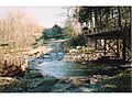
Bridge on the upper reaches
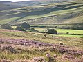
View into the valley of the Borthwick Waters


Individual evidence
- ↑ a b Information in the Gazetteer for Scotland
- ^ Borthwick in: FH Groome (ed.): Ordnance Gazetteer of Scotland: A Survey of Scottish Topography, Statistical, Biographical and Historical , Grange Publishing Works, Edinburgh, 1882-1885.