
Bottenbroich


Bottenbroich (sometimes called Alt-Bottenbroich ) is a former district of Türnich , which was relocated to Neu-Bottenbroich from 1949 to make way for the Frechen open -cast lignite mine . The place was then excavated together with the Bottenbroich monastery .
The place was east of today's Marienfeld on the western edge of the Sibylla mine field , wedged between the areas Sibylla North and South . When the Sibylla field was to be merged with various other fields to form the Frechen open- cast mine in the middle of the 20th century , the location stood in the way of expansion. That is why it was moved to Neu-Bottenbroich in 1949, with a population of 925 at the time, as the first place to develop the opencast mine . The relocation had been planned since the 1930s, but was postponed because of the Second World War.
The parish of St. Mary's Assumption in Frechen - Grefrath was the successor to the parish of Bottenbroich under canon law . The miraculous image of the Pietà and all cult objects were taken there.

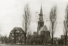
School in Bottenbroich, 1930
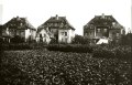
Demolition of the houses in Bottenbroich, 1948
literature
- Volker Schüler , Hans Porschen: The monastery village Bottenbroich on the Ville . In: Documenta Berchemensis historica . tape 12 . dbh, Frechen 2009, DNB 999381180 , p. 167 .
Web links
Individual evidence
- ↑ Lost places, submerged villages, dredged over and devastated, villages destroyed by open-cast mining . Archived from the original on February 10, 2009. Info: The archive link was automatically inserted and not yet checked. Please check the original and archive link according to the instructions and then remove this notice. Retrieved February 6, 2009.
- ↑ The dying Bottenbroich . In: Kölnische Rundschau . April 11, 1947. Retrieved February 6, 2009.
- ↑ Destination Marienfeld (PDF; 555 kB) RWE. Retrieved February 6, 2009.
- ↑ Königlich Preußische Landesaufnahme (Ed.): Mes table sheet "Kerpen" (No. 5106) . Prussian new admission . 1902 ( Online at GeoGREIF - Digital Collections of the University of Greifswald). Online ( Memento of the original from April 29, 2011 in the Internet Archive ) Info: The archive link was inserted automatically and has not yet been checked. Please check the original and archive link according to the instructions and then remove this notice.
Coordinates: 50 ° 53 ′ 37.8 ″ N , 6 ° 45 ′ 46 ″ E