Bowie (Maryland)
| Bowie | ||
|---|---|---|
 MD 564 on Chapel Avenue, Old Town Bowie, Maryland |
||
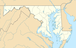
| Location in Maryland | ||
|
|
||
| Basic data | ||
| Foundation : | 1870 | |
| State : | United States | |
| State : | Maryland | |
| County : | Prince George's County | |
| Coordinates : | 38 ° 58 ′ N , 76 ° 45 ′ W | |
| Time zone : | Eastern ( UTC − 5 / −4 ) | |
| Residents : | 58,393 (as of 2016) | |
| Population density : | 1,400.3 inhabitants per km 2 | |
| Area : | 41.8 km 2 (approx. 16 mi 2 ) of which 41.7 km 2 (approx. 16 mi 2 ) is land |
|
| Height : | 47 m | |
| Postcodes : | 20715-20721 | |
| Area code : | +1 301 | |
| FIPS : | 24-08775 | |
| GNIS ID : | 0597104 | |
| Website : | www.cityofbowie.org | |
| Mayor : | G. Frederick Robinson | |
Bowie is a city in the US state of Maryland .
According to an estimate by the US Census Bureau (2016), the city had almost 60,000 inhabitants. It has an area of 41.8 km² of which only 0.1 km² is water and is located at the coordinates 38 ° 57 '53 "north, 76 ° 44' 40" west.
history
The city's official founding year is 1870 as Huntington City and is closely related to the construction of the railways in North America. In 1880 the city was given its current name Bowie .
sons and daughters of the town
- Paul Reed Smith (* 1956), guitar maker
- Brad Schumacher (* 1974), swimmer
- Daniel Cates (* 1989), poker player
Web links
Commons : Bowie (Maryland) - Collection of pictures, videos and audio files
