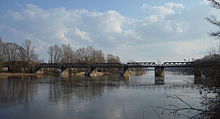
Bridge over the Old Elbe
The bridge over the Old Elbe ( listed as a monument in the local monument register under registration number 094 76764, locally also known as the Kanonenbahnbrücke ) is a listed railway bridge in Magdeburg in Saxony-Anhalt .
location
The bridge is part of the disused Biederitz – Magdeburg-Buckau railway line . It leads from the Magdeburg districts of Brückfeld and Cracau in the east to the west to the Elbe island Rotehorn , bridging the Old Elbe .
Architecture and history
The approximately 220 meter long bridge was built in the 1840s as part of the construction of the Berlin – Magdeburg railway line by the Berlin-Potsdam-Magdeburg railway company . The structure has nine openings, each of which is spanned by a single-span girder with two parallel- belted , riveted lattice girders arranged above the roadway .
After the route in the Magdeburg area was re-routed, the Biederitz – Magdeburg-Buckau railway lost its importance and was finally shut down in 1998.
There are plans to tear down the bridge. The background are cost arguments and concerns that the bridge would be problematic in the course of flood protection . Other considerations, which have not yet achieved a majority in Magdeburg's city council, include maintaining the bridge, upgrading it for flooding and converting it into a cycle path.
literature
- List of monuments Saxony-Anhalt, Volume 14, State Capital Magdeburg , State Office for Monument Preservation and Archeology, Michael Imhof Verlag, Petersberg 2009, ISBN 978-3-86568-531-5 , page 161
- Ingelore Buchholz, Jürgen Buchholz: Magdeburg Elbbrücken . In: City Planning Office Magdeburg (ed.): Documentation 40/05 . S. 111, 112 .
Web links
Individual evidence
- ↑ List of monuments in Saxony-Anhalt (PDF, page 2561)
- ↑ a b Katja Tessenow, Monument heads for demolition in the Magdeburger Volksstimme, published online on March 20, 2016
- ^ Karl-Heinz Kaiser, Königslibelle versus Strombrücke - old cannon train to be an exchange object in the Magdeburger Volksstimme, published online on March 29, 2012
Coordinates: 52 ° 7 ′ 31.2 ″ N , 11 ° 39 ′ 5.2 ″ E


