Cracau (Magdeburg)
|
Cracau district of Magdeburg |
|
|---|---|
| Basic data | |
| Surface: | 2.6263 km² |
| Residents : | 8466 |
| Population density : | 3,224 inhabitants per km² |
| (Information as of December 31, 2016) | |
| Coordinates : | 52 ° 7 ' N , 11 ° 40' E |
| Districts / Districts: | Old Cracau Settlement Cracau Wiesengrund / Zur Pappel Stadium |
| Postal code : | 39114 |
| Tram lines : | 4th |
| Bus routes : | 56 |
Cracau is a district of the Saxony-Anhalt state capital Magdeburg . 8466 inhabitants live in an area of 2.6 km² (as of December 31, 2016).
geography
The district is located directly on the east bank of the Elbe at an altitude between 45 and 50 meters above sea level. It is 2.1 kilometers from the center of Cracow to the city center of Magdeburg. There is a direct tram connection. The neighboring districts from north to south are Brückfeld , Berliner Chaussee , Zipkeleben and Prester . In terms of urban planning, Cracau can be classified as a purely residential area.
history
Archaeological finds have shown that the area of today's Cracaus was already inhabited by Teutons on two flood-free sand islands during the Roman Empire (around 300 AD) . Later Slavs settled there, who gave the place the name Krakov in their language, which can be interpreted as the "place of Krak". The settlement was largely surrounded by swamp meadows, but there was already a road connection to the east with the Gübser Damm.
The place was first mentioned as Cracowe in 1160 in connection with the settlement of Dutch immigrants by the Magdeburg Provost. At that time, the construction was carried out along a crossroad that is now Potsdamer and Babelsberger Strasse as well as Simon and Burchardstrasse. The first church was apparently also built by the Dutch; it was consecrated on July 9, 1164 to St. Briccius .
During the Thirty Years' War Cracau was occupied by the imperial general Pappenheim . In an attempt by Magdeburg troops to drive Pappenheim on September 8, 1629, Cracau was largely destroyed. A second wave of destruction hit the place in 1631 when Tilly's army stormed Magdeburg . The reconstruction lasted until around 1660, the destroyed St. Briccius Church was not restored until 1661. In the following three hundred years Cracau kept its village character and its inhabitants lived mainly from agriculture.
With industrialization in the 19th century, the previous village gradually transformed into a workers' settlement. The resulting close ties to Magdeburg led to the final incorporation in 1910. The official gazette read: "On April 1, 1910, the rural community of Krakow was separated from the district of Jerichow I and added to the urban district of Magdeburg."
As early as 1889, the Magdeburg Evangelical Superintendent Gustav Adolf Pfeiffer established the Johannisstift nursing home, which in the following years was continuously developed into a nursing home for the infirm and physically handicapped and to this day into the large hospital and nursing complex " Pfeiffersche Stiftungen " increased. Soon after the incorporation, plans emerged for further development of the district in a north-easterly direction. They were finally realized in the years between 1929 and 1938 with the establishment of the “Cracau Settlement”, predominantly in the forms of the architecture of the so-called “New Building” of the 1920s. The foundations were laid by the former town planning officer and well-known architect Bruno Taut in 1923 with his general settlement plan , while the architects Johannes Göderitz and Carl Krayl took over the execution. After the construction of the settlement was essentially completed in 1938, it could be considered one of the largest social housing complexes with around 2000 apartments. With a 5400-meter-long tram line that went into operation on November 13, 1928, the infrastructure continued to improve, and Cracau had finally assumed urban character.
While the city center of Magdeburg was almost razed to the ground by bombing during the Second World War , Cracau suffered comparatively little bomb damage. While the urban area of Magdeburg west of the Elbe had already been taken by American troops on April 18, 1945, the Red Army did not occupy Cracau until May 5, 1945. The Soviet city commandant set up a separate city administration for the eastern urban areas, which was active until Magdeburg was completely taken over by the Red Army on July 1, 1945. Magdeburg became a Soviet garrison town, which for Cracau had the consequence that in several streets near the Elbe the house owners were expropriated in favor of Soviet officers' apartments. Until the end of the GDR rule, Cracau's infrastructure was not significantly further developed, apart from the construction of the Catholic St. Andrew's Church in 1951, the Ernst Grube Stadium on the eastern edge of the district, which can hold 40,000 spectators, in 1955 and the minor expansion the Cracau settlement.
After 1990 Cracau quickly developed into one of the most popular residential areas in Magdeburg. The Cracau settlement was continuously renovated through targeted municipal and supraregional funding programs, and several new settlement areas were created for both apartment buildings and private homes. The new construction of the Magdeburg Stadium - a modern football arena on the site of the former Ernst Grube Stadium - represents a highlight of the urban development .
Population development
- 1782: 265
- 1840: 459
- 1900: 3,912
- 1933: 4,936
- 1946: 5,547
- 1998: 7,559
- 2006: 8,710
Attractions
The cultural monuments in the district are listed in the local monument register .
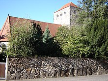
In the southwest of Cracow is the St. Briccius Church , built in 1661, with a Romanesque tower and early Baroque nave. The listed resting place of Gustav Adolf Pfeiffer is located in the Ostfriedhof Magdeburg in Cracau .
Also in this historical part of Cracow there are a few rayon houses in addition to the few preserved farmhouses . These were built according to the regulations for the so-called fortress pale in half-timbered style in the middle of the 19th century. At the end of the 1990s, one of these buildings on Burchardstrasse was completely renovated.
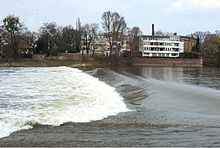
In the Elbarm called the " Old Elbe ", a weir was built in at the level of Cracau , which is generally known as the " Cracau Waterfall ".
North of the weir, the bridge at the waterfall was built as a pedestrian bridge over the Old Elbe in 1996 . It is 232.5 meters long and was designed as a cable-stayed bridge with a 42-meter-high A-shaped steel pylon including piers .
Web links
Individual evidence
- ↑ District catalog of the Office for Statistics
- ↑ Administrative region of Magdeburg (Ed.): Official Gazette of the Government of Magdeburg . 1910, ZDB -ID 3766-7 , p. 163 .
- ↑ http://www.magdeburg.de/media/custom/698_8076_1.PDF?1254747004


