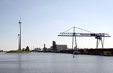
North industrial area
|
Commercial area north district of Magdeburg |
|
|---|---|
| Basic data | |
| Surface: | 9.3877 km² |
| Residents : | 12 |
| Population density : | 1 inhabitant per km² |
| (Information as of December 31, 2016) | |
| Coordinates : | 52 ° 12 ' N , 11 ° 40' E |
| Districts / Districts: | August-Bebel-Damm harbor , Barleber Wiese |
| Postal code : | 39126 |
| Tram lines : | 10 |
| Bus routes : | 704 ( NJL ) |
Industrial area north is a district of Magdeburg , the state capital of Saxony-Anhalt .
Location and geography
The district in the north of the city near the Elbe has an area of 9.3877 km². Only 12 people (as of December 31, 2016) have their main residence here. The district mainly serves as a commercial area.
To the north is the Barleber See district . In the east, the Rothensee descent canal and the Elbe form the district boundary . In the south are the districts of Industriehafen and Rothensee , to the west of Neustädter See .
With the Kelterer Pond and the Erdkuhle there are also two lakes in the district. In the north, the shot flows through the area. Parts of the port of Magdeburg are located in the eastern part of the district . This also includes the Magdeburg canal and Steinkopfinsel . The cultural monuments in the district are listed in the local monument register .
history
Industrial use of the area already existed in the first half of the 20th century . The location on the Elbe, the Mittelland Canal , important railway lines and the autobahn offered favorable opportunities for business establishments. Intensive use by several large companies continued during the GDR era . In the time after the political change , extensive efforts were made to continue the area as Magdeburg's industrial area. The August-Bebel-Damm , which runs through the district from south to north , was expanded to include four lanes. The previously little-used area west of the main road was developed as a large industrial area. From 2004 the Hansehafen was built on the descent canal from the Magdeburg waterway intersection .
The occasionally somewhat stronger use as a residential location no longer exists today. In 1993 210 people lived in the district, in 2002 7.
economy
In accordance with the function of the district as an industrial area, several larger companies have settled in the area, which is conveniently located between the Elbe, Mittelland Canal, federal motorway 2 and larger railway lines. Better known are the wind turbine manufacturer Enercon and the organic oil plant Magdeburg .
Buildings
The existing cultural monuments in the district are listed in the local register of monuments, including the administration building August-Bebel-Damm 17, 19 and the Rothensee substation used by the Technical Police Office .
literature
- 40 Quarter in the big test , Magdeburg, 2003, page 48 f.


