Barleber See (district)
|
Barleber See district of Magdeburg |
|
|---|---|
| Basic data | |
| Surface: | 5.4147 km² |
| Residents : | 61 |
| Population density : | 11 inhabitants per km² |
| (Information as of December 31, 2016) | |
| Coordinates : | 52 ° 13 ' N , 11 ° 40' E |
| Districts / Districts: | Barleber See I Barleber See II Ship lift Autobahn connection point Schrote / Autobahn |
| Postal code : | 39126 |
Barleber See is the northernmost district of Magdeburg , the state capital of Saxony-Anhalt .
Population and location
61 people (as of December 31, 2016) live with their main residence in an area of 5.4147 km². In the south, the district is bounded by the Federal Motorway 2 and in the north by the Mittelland Canal . The municipality of Barleben borders to the west and the city of Wolmirstedt to the east .
The district is characterized by the lakes Barleber See I and Barleber See II , to which the district owes its name and which, at 1.749 km², take up a large part of the area of the district. The meal also flows through the district, taking in the small aspic and large aspic .
The district does not have a uniform settlement structure or its own town center. In the far east of the district is the Schiffshebewerk settlement , the eastern part of which already belongs to Wolmirstedt. Settlements for local recreation emerged around Barleber See I. To the north of the lake is the Barleber See fishing colony with around 170 bungalows and to the south the local recreation center Am Barleber See with a further 70 bungalows. To the east of the lake there is a campsite with 625 places for permanent campers , which corresponds to around 1,500 people, and 250 additional places for vacationers and travelers (status 2003).
history
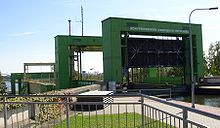
With the construction of the autobahn and the Mittelland Canal in the 1920s and 1930s, because of the gravel mining that took place here, Lake Barleber I was initially created. In the easternmost part of today's district, the Rothensee ship lift , which was completed in 1938 and connects the Mittelland Canal with the Elbe , was built. In this context, the ship lift settlement was also created. The Barleber See I became a local recreation center after the end of gravel mining. The gravel mining continued further east and led to the creation of the Barleber See II. Gravel is still extracted here today.
In the 1990s, the Magdeburg waterway intersection was built, the western part of which, in particular the Rothensee sluice lock, is located in the area of the district.
The cultural monuments in the district are listed in the local monument register .
economy
Due to the waterway cross and the local recreation around the Barleber See I, tourism has a certain importance in addition to gravel extraction. With the Magdeburg-Barleber See stop in the west, the district is connected to the Mittelelbe S-Bahn .
literature
- 40 quarter in the big test , Magdeburg 2003, page 16 f.


