
Bramfelder Dorfgraben
| Bramfelder Dorfgraben | ||
 |
||
| Data | ||
| location | Hamburg - Bramfeld | |
| River system | Elbe | |
| Drain over | Seebek → Osterbek → Alster → Elbe → North Sea | |
| origin | west of the Bramfeld village square 53 ° 36 ′ 52 ″ N , 10 ° 4 ′ 29 ″ E |
|
| Source height | approx. 18 m above sea level NHN | |
| muzzle | In the Seebek coordinates: 53 ° 36 ′ 54 " N , 10 ° 4 ′ 6" E 53 ° 36 ′ 54 " N , 10 ° 4 ′ 6" E |
|
| Mouth height | approx. 15 m above sea level NHN | |
| Height difference | approx. 3 m | |
| Bottom slope | approx. 7 ‰ | |
| length | approx. 430 m | |
| Navigable | No | |
The Bramfelder Dorfgraben is a creek around 430 meters long in Hamburg - Bramfeld . It begins about 90 meters west of Bramfelder Village Square and Bramfelder Chaussee (former Federal Highway 434 ) at the upper end of a public park and flows in western direction, said Fabricius road and the Günselstieg be crossed, then as their only flow into the Seebek lead to , which forms the border between Bramfeld and Steilshoop .
The green area in the upper section of the trench should have been part of the tram route between Steilshoop and Bramfeld. After the tram plans were discontinued, a new thoroughfare between Bramfelder Chaussee and Fabriciusstraße and several new residential buildings are under construction. The Bramfelder Dorfgraben will be redesigned.

origin

Course within the green area
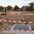
Modification (as of October 2018)


Web links
Individual evidence
- ↑ a b c Geo-Online Hamburg
- ↑ Zoning plan Bramfeld 64 , accessed on September 29, 2015