
Fire head (case)
| Brandkopf | ||
|---|---|---|
.jpg) South side of the Brandkopf above the Röthenbachalm |
||
| height | 1258 m above sea level NHN | |
| location | Germany ( Bavaria ) | |
| Mountains | Bavarian Prealps | |
| Dominance | 0.8 km → Geißkopf | |
| Notch height | 84 m | |
| Coordinates | 47 ° 35 '41 " N , 11 ° 34' 46" E | |
|
||

The Brandkopf is the westernmost peak on the mountain range of the Schergenwieser Berg , which separates the Sylvensteinspeicher in the south from the Isar valley to Lenggries in the north.
The lightly wooded summit can only be reached without a path. B. on the south side from the dilapidated Röthenbachalm .
gallery
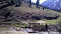
Dilapidated Röthenbachalm on the south side

Summit area

,_Gipfel.jpg)