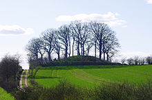
Brautberg


The Brautberg is a burial mound from the older Bronze Age in / near Bordesholm in the Rendsburg-Eckernförde district in Schleswig-Holstein . It is almost round with a diameter of approx. 35 m and a height of approx. 8 m (but appears higher because it is located on a hilltop) and consists of trees and bushes. Its top is a small plateau, which with a height of 41 m is one of the highest points in the area, which is why it is also designated as a lookout point. It has been a listed building since 1971 and is located directly north of the L 49 in a field and can be freely entered.
The burial mound is dated to around 1700 BC. Chr. Dated. A large stone grave is suspected in the interior of the hill after preliminary investigations . The mound itself was enlarged by subsequent burials in tree coffins . Later urns were also buried in the mound.
Surname
The name of the Bride Mountain is traced back to the custom that
- Brides said goodbye to their ancestors by circumnavigating the Bride Mountain before joining their husband's family.
- Bridal couples came there to ask for the ancestral blessings.
Others
- Directly northeast of the Brautberg (as well as in the Brautberg itself), the largest urn field in Schleswig-Holstein with at least 5500 burials was discovered and archaeologically examined.
- During construction work on the adjacent L 49, four large boulders were found, one of which is a cup stone with four or five elongated depressions. The stones were placed in a group on the flank of the Brautberg.
- The Brautberg is the last remaining burial mound of what used to be numerous in the area.
- The top of the Brautberg is used today for civil weddings .
swell
- Information board of the State Office for Monument Preservation on the Brautberg
- Information board of the "Bordesholmer Kulturwanderweg" on the Brautberg
- Johannes Hugo Koch - DuMont Art Guide Schleswig-Holstein, Cologne 1983
- http://www.bordesholm.de/kultur/wanderweg/kw13.html
- http://www.megalithic.co.uk/article.php?sid=12815
Web links
Coordinates: 54 ° 11 ′ 14.6 ″ N , 10 ° 1 ′ 3 ″ E

