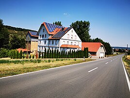
Broad mill
|
Broad mill
City of Lauda-Königshofen
Coordinates: 49 ° 31 '12 " N , 9 ° 42' 13" E
|
|
|---|---|
| Postal code : | 97922 |
Wide mill , formerly only Mill is a former mill and a contemporary living space within the boundaries of the Lauda King Hofener district Sachsenflur in Main-Tauber-Kreis in Franconia dominated northeastern Baden-Wuerttemberg .
geography
With half a dozen buildings, Breite Mühle is about 500 meters southwest of Sachsenflur in the Umpfertal . Immediately in front of the mill, a mill canal branches off to the right, which flows into the Umpfer from the right shortly after the mill. Other places nearby are the Talhof after about 750 meters in the south-southwest and Unterschüpf after about one kilometer in the southwest.
history
On the table sheet No. 6424 "Königshofen" from 1881 the place was recorded as a mill . The Mühle residential area is considered to have merged into today's Breite Mühle residential area.
As part of the regional reform in Baden-Württemberg as part of the formerly independent municipality of Sachsenflur, the Breit Mühle residential area came to the city of Königshofen on January 1, 1972 together with Deubach and Messelhausen. On January 1, 1975, the city of Königshofen Lauda merged with the city of Lauda and the community of Unterbalbach to form the city of Lauda-Königshofen. Other formerly independent communities were added.
Cultural monuments
Cultural monuments in the vicinity of the residential area are recorded in the list of cultural monuments in Lauda-Königshofen .
traffic
The place is directly on the B 292 between Sachsenflur and Unterschüpf. In Sachsenflur this is known as Sachsenstraße up to the end of the town in the direction of the Breiten Mühle .
Web links
- Breite Mühle - Wohnplatz und Mühle - opened on the website www.leo-bw.de
Individual evidence
- ↑ a b German Photo Library. In: deutschefotothek.de. Retrieved August 11, 2020 .
- ↑ a b c Breite Mühle - living space - detail page - LEO-BW. In: leo-bw.de. Retrieved August 10, 2020 .
- ↑ Mühle - Aufgommen - Detail page - LEO-BW. In: leo-bw.de. Retrieved August 10, 2020 .
- ^ Federal Statistical Office (ed.): Historical municipality directory for the Federal Republic of Germany. Name, border and key number changes in municipalities, counties and administrative districts from May 27, 1970 to December 31, 1982 . W. Kohlhammer, Stuttgart / Mainz 1983, ISBN 3-17-003263-1 , p. 480 .
- ^ Federal Statistical Office (ed.): Historical municipality directory for the Federal Republic of Germany. Name, border and key number changes in municipalities, counties and administrative districts from May 27, 1970 to December 31, 1982 . W. Kohlhammer, Stuttgart / Mainz 1983, ISBN 3-17-003263-1 , p. 469 f .
