Briesener Bach
|
Briesener Bach Great Briesener Bach |
||
| Data | ||
| Water code | DE : 587284 | |
| location | Potsdam-Mittelmark district , Brandenburg , Germany | |
| River system | Elbe | |
| Drain over | Verlorenwasser → Buckau → Havel → Elbe → North Sea | |
| source | at Groß Briesen 52 ° 14 ′ 38 ″ N , 12 ° 29 ′ 27 ″ E |
|
| muzzle | southwest of Wollins das Verlorenwasser Coordinates: 52 ° 16 ′ 19 ″ N , 12 ° 26 ′ 32 ″ E 52 ° 16 ′ 19 ″ N , 12 ° 26 ′ 32 ″ E
|
|
| length | 4.8 km [1] | |
| Catchment area | 17.34 km² [2] | |
| Small towns | Bad Belzig with part of the municipality Groß Briesen | |
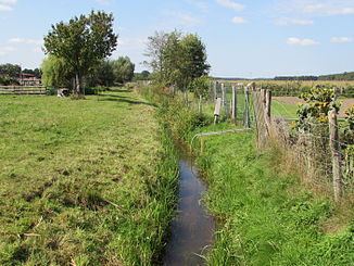
The Briesener Bach or Groß Briesener Bach rises in the village of Groß Briesen in the High Fläming, which belongs to Bad Belzig, and drains to the northwest to the Verlorenwasser . It is the longest tributary of the Lost Water.
course
The trench-like, little natural Briesener Bach with a length of about 4.8 kilometers drains a flat and partly boggy glacial valley of the northern High Fläming near Groß Briesen south of the Briesener Mountains. He follows this valley in a north-westerly direction. Other localities are not affected. In the municipality of Wollin , the stream finally flows into the lost water at a former mill. The Briesener Bach has a catchment area of 17.34 square kilometers.
Protected areas
The Briesener Bach is located in several protected areas. So he is on whole length in the High Fläming Nature Park , in the conservation area High Fläming - Belziger Landschaftswiesen and FFH area Buckau and side leveling supplement. There is also a protected biotope in the headwaters .
Individual evidence
- ↑ State of Brandenburg biodiversity in the Flämingfließen ( memento of the original from July 14, 2014 in the Internet Archive ) Info: The archive link was inserted automatically and has not yet been checked. Please check the original and archive link according to the instructions and then remove this notice. . Accessed June 8, 2014.
- ^ Partial sheet Southwest Protected Areas. In: Landkreis Potsdam-Mittelmark landscape framework plan. Office for Environmental and Landscape Planning, archived from the original on August 7, 2011 ; Retrieved June 7, 2014 .
