
Buckau (river)
| Buckau | ||
 |
||
| Data | ||
| Water code | EN : 5872 | |
| location | Northern edge of the Hohen Fläming , Fiener Bruch , Brandenburg-Neustädter Heide | |
| River system | Elbe | |
| Drain over | Havel → Elbe → North Sea | |
| source | south of Görzke | |
| Source height | 95 m | |
| muzzle | South bank of Breitlingsee Coordinates: 52 ° 21 '57 " N , 12 ° 27' 44" E 52 ° 21 '57 " N , 12 ° 27' 44" E |
|
| Mouth height | 28 m | |
| Height difference | 67 m | |
| Bottom slope | 2 ‰ | |
| length | 34.1 km | |
| Catchment area | 427.8 km² | |
| Discharge at the Herrenmühle gauge, trout facility A Eo : 135 km² Location: 19.7 km above the mouth |
NNQ (08/09/1998) MNQ 1980–1999 MQ 1980–1999 Mq 1980–1999 MHQ 1980–1999 HHQ (03/02/1996) |
367 l / s 392 l / s 608 l / s 4.5 l / (s km²) 1.87 m³ / s 3.47 m³ / s |
| Left tributaries | Krummer Bach , Geuenbach | |
| Right tributaries | Riembach , Strepenbach , Strynzelbach , Verlorenwasser | |
| Medium-sized cities | Brandenburg on the Havel | |
| Small towns | Ziesar | |
| Communities | Buckautal , Görzke , Wenzlow | |
The Buckau is a tributary of the Havel in Brandenburg . It is one of the four major natural rivers on the north side of the Hohen Fläming in the Potsdam-Mittelmark district , which includes the Buckau, the Plane , the Verlorenwasser and the Temnitz . The river is 34 km long and flows into the Breitlingsee in the city of Brandenburg an der Havel , through which the Havel flows.
Surname
The name of Buckau is of Slavic origin and means Buchenbach. In medieval documents, the Buckau is sometimes called "Grobion", which can be seen in connection with the deserted "trenches" that lay on its lower reaches just before the mouth. Today the Wendgräben residential area still refers to the abandoned settlement of the Middle Ages.
course
The source of Buckau, which has been left in its natural state for long stretches, is about one kilometer from the municipality of Görzke , on the south-eastern slope of the 126-meter-high Bullenberg at a height of 95 m. The river thus overcomes about 67 meters in altitude to its mouth, which is about 28 meters. After the Buckau has passed Görzke to the west, it takes up the Riembach, which is about the same length and is also known as the Buckau's second spring stream, at the birch rice mill between the villages of Rottstock and Buckau . This has its origin northeast of Görzke, between Görzke and the desert Dangelsdorf on the edge of the Nonnenheide.
The Buckau flows through the village of the same name, passes the village of Köpernitz to the east and the town of Ziesar about two kilometers away. At Bücknitz , whose name is borrowed from the Buckau ("Buckaudorf"), the Buckau leaves the Fläming. From there to the Fiener Bruch there is an extensive alluvial cone , the Bücknitzer Heide , which was washed up by the Buckau. Before entering the Fiener Bruch, the Buckau passes the Eulenmühle northwest of Glieneckes and flows northeast of the Bücknitz Heath across the Fiener Bruch, which is considered part of the Glogau-Baruther glacial valley . Furthermore, the Buckau passes the southern edge of the Karower Platte , which was formed during the Ice Age, and the villages of Viesen and Mahlenzien and the Mahlenziener Sander (Marcinek 1961).
After the Buckau has taken in its tributary Verlorenwasser about one kilometer east of the Brandenburg district of Mahlenzien, it turns back north in a wide arc. In doing so, she touches the residential areas Neue Mühle and Wendgräben, which have belonged to Brandenburg an der Havel and Neustadt Brandenburg since the Middle Ages and are of the Waldweiler settlement type. A few hundred meters behind Wendgräben, the Buckau passes under Magdeburger Heerstraße, an old trade route from Magdeburg via Ziesar to Brandenburg an der Havel that has been in use since the Middle Ages , and about a kilometer north of the Berlin - Magdeburg railway line . The swampy estuary begins north of the railway bridge with a thickly overgrown alder forest . The Buckau flows into the Havelsee Breitling near the Malge excursion destination. It is the last Fläming river to be absorbed by the Havel.
In the Buckau in Fiener Bruch, a flow rate of 0.2 to 0.3 meters per second was measured. The Havel supplies the river with around 2 cubic meters of water per second. The Buckau drains a catchment area of 427.8 square kilometers. The Buckau's biological water quality is given as quality class II over its entire length. The river is considered to be moderately polluted. Several weirs or barrages are installed.
Tributaries and ditches
Several natural rivers and artificial ditches flow into the Buckau. The amelioration ditches were partly created on the basis of natural rivers. There are collaterals between individual rivers through which water can flow from one system to another. Examples are the Holzgraben between the Holzbuckau and the Verlorenwasser or the Zitzer and the Karower Landgraben , which connect the Buckau to the Elbe-Havel Canal .
- Riembach
- Crooked brook
- Geuenbach
- Herrenmühlengraben
- Strynzelbach
- Strepenbach
- Buckauer main ditch in the upper reaches as Kobser Bach
- Holzbuckau
- Lost water
Economic use

In earlier centuries the Buckau was used as a mill-driving body of water. For this purpose barrages and water mills were installed in several places . The Buckau mills were primarily used to grind grain. The river lost its economic importance when the mills were largely shut down. However, some systems are still functional and in occasional use. The owl mill, for example, is still used now and then and not commercially as a sawmill . Several Buckau watermills were converted into hydropower plants and have been used to generate electricity ever since. For example, the Eulenmühle and the Kruger Mill feed electricity into the public grid. Fish ponds were often created at the barrages . These are used as fishing waters or as breeding stations. Furthermore, the use of the Buckau river basin for tourism with its floodplains and mixed forests is becoming more and more important. The Buckau is not navigable along its entire length or it is closed for long stretches for canoe trips all year round.
Protected areas
In the course of the Buckau flows through several partially overlapping protected areas. To east Ziesars it is for example in High Fläming Nature Park and conservation area High Fläming - Belziger Landschaftswiesen. It is also designated as a FFH area Buckau and tributaries. Several sections of the river have been placed under protection as protected biotopes . From the west of Bücknitz to the Brandenburg city area, the Buckau flows through the Fiener Bruch bird sanctuary ( SPA area ). The landscape protection area of Brandenburg forest and lake area begins shortly after the city limits, in which the entire lower reaches up to the mouth lies. The estuary itself is located in the nature reserve and FFH area Gränert.
Flora and fauna
Mammals native to Buckau are, for example, beavers and otters that have immigrated again via the Havel. Furthermore, white-tailed eagles and ospreys and other bird species live along the river and use it. Notable - and protected - amphibian species are, for example, crested newt and moor frog , fish the brook lamprey . The biodiversity of plants is also rich. Examples of plants occurring in the Buckau are marsh marigolds , crab claws , frog bites , real valerian and silver grass .
gallery

The source of the Buckau, southwest of Görzke / Fläming
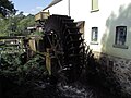
The owl mill on the middle course near Glienecke

The Buckau at the weir system at the old tower of the Landwehr of the new town of Brandenburg near the Neue Mühle

The mouth of the Buckau in the Breitlingsee


swell
- Surroundings of Brandenburg (Havel), 1: 100,000, Reichsamt für Landesaufnahme Berlin, 1938
- District of Belzig, 1: 100,000, VEB Hermann Haack, Geographisch-Kartographische Anstalt Gotha, 1965
- Topographic map 1:50 000, L3740 Wusterwitz, land surveying and geographic base information Brandenburg, Potsdam 2003
Web links
Footnotes
- ↑ River directory gewnet25 (Version 4.0, April 24, 2014) from the Ministry for Rural Development, Environment and Agriculture of the State of Brandenburg, accessed on May 4, 2015.
- ^ German Hydrological Yearbook Elbe Region, Part II 1999 Brandenburg State Environment Agency, p. 151, accessed on November 3, 2018, at: lugv.brandenburg.de (PDF, German).
- ^ Breckow, Ortschronik von Kirchmöser, Ed. Borstel, Kirchmöser, Brandenburg an der Havel 1936/2006
- ↑ State of Brandenburg biodiversity in the Flämingfließen ( memento of the original from July 14, 2014 in the Internet Archive ) Info: The archive link was inserted automatically and has not yet been checked. Please check the original and archive link according to the instructions and then remove this notice. . Accessed June 8, 2014.
- ↑ explicit information in state surveying and geographic base information Brandenburg (ed.) :, topographic map 1: 50,000 L3940 (current status: 2013)
- ↑ a b c Brandenburg an der Havel and surroundings - a landscape inventory in the area of Brandenburg an der Havel, Pritzerbe, Reckahn and Wusterwitz, eds. Sebastian Kinder and Haik Thomas Porada, in the series Landscapes in Germany - Values of the German homeland of Leibniz- Institutes for Regional Geography and the Saxon Academy of Sciences in Leipzig, Volume 69, published by Böhlau Verlag Köln Weimar Vienna, 2006, ISBN 978-3-412-09103-3 , p. 294
- ^ Partial sheet Northwest Surface Waters. In: Landkreis Potsdam-Mittelmark landscape framework plan. Office for Environmental and Landscape Planning, archived from the original on August 7, 2011 ; Retrieved October 16, 2013 .
- ↑ Cycle and waterway map Havelseen 1 Brandenburg / Havel , Verlag green heart, Ilmenau, 2011, ISBN 978-3-935621-52-6 .
- ↑ Part sheet Northwest Protected Areas. In: Landkreis Potsdam-Mittelmark landscape framework plan. Office for Environmental and Landscape Planning, archived from the original on August 7, 2011 ; Retrieved October 16, 2013 .
- ^ Partial sheet Southwest Protected Areas. In: Landkreis Potsdam-Mittelmark landscape framework plan. Office for Environmental and Landscape Planning, archived from the original on August 7, 2011 ; Retrieved June 7, 2014 .
- ^ Brandenburg an der Havel landscape protection areas in the area of the city . Accessed June 7, 2014.
- ↑ Brandenburg an der Havel Flora Fauna Habitat (FFH) areas . Accessed June 7, 2014.
- ^ Brandenburg an der Havel nature reserves in the city area . Accessed June 7, 2014.
- ^ NABU Foundation Gränert Brandenburg an der Havel . Accessed June 8, 2014.