
Ziesar
| coat of arms | Germany map | |
|---|---|---|

|
Coordinates: 52 ° 16 ' N , 12 ° 17' E |
|
| Basic data | ||
| State : | Brandenburg | |
| County : | Potsdam-Mittelmark | |
| Office : | Ziesar | |
| Height : | 55 m above sea level NHN | |
| Area : | 67.94 km 2 | |
| Residents: | 2510 (Dec. 31, 2019) | |
| Population density : | 37 inhabitants per km 2 | |
| Postal code : | 14793 | |
| Area code : | 033830 | |
| License plate : | PM | |
| Community key : | 12 0 69 696 | |
| LOCODE : | DE ZSR | |
| City structure: | Core city and 3 districts | |
City administration address : |
Mühlentor 15a 14793 Ziesar |
|
| Website : | ||
| Mayor : | Dieter Sehm ( SPD ) | |
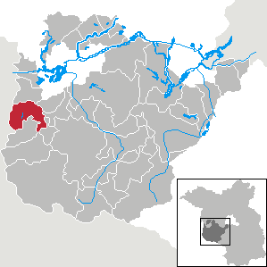
| Location of the town of Ziesar in the Potsdam-Mittelmark district | ||
  |
||

Ziesar [ t͡siˈeːzaʁ ] is a town in the Brandenburg district of Potsdam-Mittelmark and the seat of the Ziesar office . Its landmark is Ziesar Castle .

geography

The city of Ziesar is located in the far west of the state of Brandenburg and the district of Potsdam-Mittelmark. Paplitz to the west belongs to the city of Genthin in the Jerichower Land district of Saxony-Anhalt . To the north, Ziesar borders the municipality of Rosenau , to the east to Wenzlow and to the southeast to Gräben and Görzke . To the south lies the municipality of Buckautal and to the south-west, Möckern, which in turn belongs to Saxony-Anhalt . A small exclave , the eastern part of which belongs to the town of Ziesar, is located in the urban area of Möckern in Saxony-Anhalt (its western part belongs to the municipality of Buckautal as well as four neighboring Brandenburg exclaves), and vice versa there is an enclave that belongs to Möckern, in Ziesars Urban area.
Ziesar is located directly on the northern slope of the Fläming . To the north of Bücknitz, large areas belong to the Fiener Bruch , which is part of the Baruther glacial valley . In the southern area of the glacial valley , a sandy alluvial cone was washed up by ice age meltwater , on which the Bücknitzer Heide , a pine forest , developed. Running waters in the area of the city of Ziesar are the Buckau , which drains to the Havel, with its tributaries Geuenbach , Kirchenheider Bach , Strynzelbach , Strepenbach and Litzenbach . The Kobser Bach or the Buckauer Hauptgraben flows directly through the small town.
City structure
In addition to the core city, the following districts belong to Ziesar:
Inhabited parts of the community are Grebs and Herrenmühle , residential areas in the city are Eulenmühle and Kobser Mühle.
history
.jpg)
The name of the city is derived from Polabian . Za jezero means "behind the lake". This refers to an area south of the castle in which there used to be a 2 km long and 1.5 km wide lake that was fed by springs south of the city. The lake was drained through drainage and from 1880 it was used as a hay meadow and cattle pasture. Jezer appears in several place names in the area, such as Ferchesar and Hohenferchesar .
10th to 13th centuries

The history of the place is closely connected with Brandenburg an der Havel, the diocese and the bishopric of Brandenburg , the imperial principality of the bishop of Brandenburg . Ziesar was first mentioned in 948 as Ezeri , also Secezere . This is a document drawn up by Otto I , in which the place was transferred to the Brandenburg Monastery. Ziesar was in the Brandenburg Monastery until 1571 and was de jure not part of the Mark Brandenburg .
As early as 1226, brothers of the Franciscan order founded in 1210 can be found in Ziesar. The Brandenburg prince-bishop Gernand supported the settlement. The Ziesar pastor Helias ( magister Helyas, plebanus de Secezere , died 1237), a learned priest according to his title “Magister” , founded the Ziesar monastery , which was soon moved to Brandenburg an der Havel because there had been civil unrest in Ziesar . The Holy Cross Church was built in the 13th century and a second monastery of the Cistercian women was built in the first half of the 14th century . The expansion of Ziesar Castle also took place at this time .
Ziesar was on the old Brandenburg – Magdeburg military road . Ziesar gained in importance after the Brandenburg bishop Ludwig expanded Ziesar Castle into his permanent residence. From 1327 to around 1560, Ziesar was the seat of the bishops of Brandenburg and the royal seat . The town charter was probably granted in 1373. Around 1400 the city was fortified, ramparts, moats and four city gates were built.
14th to 19th century
In 1555 the city fathers built a community hospital. The place suffered two destruction in the Thirty Years War . After the Reformation , Ziesar Castle was the seat of an electoral office from 1570 to 1820. Due to the inner-Prussian exchange of territory with Luckenwalde , the city had belonged to the Duchy of Magdeburg since 1773 and was in what was then Ziesar's district . Clay deposits were discovered near Ziesar in 1624. This raw material provided the basis for the development of a pottery industry, which was one of the city's most important industries well into the 20th century. The connection to the postal route from Berlin via Brandenburg and Ziesar to Kleve brought a further economic upswing . In 1673 the town hall burned down. Between 1860 and 1872 builders restored the Holy Cross Church. The city benefited from the connection to the highways, which was made between 1860 and 1873. In 1896/1897 the city fathers built the Westbahnhof and put a small railway into operation.
20th to 21st century
In 1900 a poor house opened on Petritor. Six years later, Ziesar was connected to the electrical grid; also opened a school. From 1911 to 1916 the small railway was rebuilt so that it was connected to the standard-gauge railways. In 1913 the district court opened; 1916 the main train station. In 1936 Ziesar was connected to the newly opened motorway from Hanover to Berlin. In 1945 the Red Army captured the city. After the end of the Second World War , refugees were housed in the castle.
In 1993, a treasure trove of coins from the reign of Frederick the Great was recovered in Ziesar . In the same year a Ziesar office was established again, the administration of which is located on the castle grounds. The places Bücknitz, Glienecke and Köpernitz were incorporated on March 1, 2002.
Administrative affiliation
- 948–1571 Hochstift Brandenburg
- 1571–1773 Zauchischer Kreis ( Electorate of Brandenburg )
- 1773–1816 Ziesarscher Kreis ( Duchy of Magdeburg )
- 1816–1947 District Jerichow I ( Province of Saxony , Prussia )
- 1947–1950 District Jerichow I (State of Saxony-Anhalt )
- 1950–1952 Burg district (State of Saxony-Anhalt )
- 1952–1990 Brandenburg-Land district ( Potsdam district )
- 1990–1993 Brandenburg district (State of Brandenburg )
- since 1993 district of Potsdam-Mittelmark (state of Brandenburg)
Incorporations
The places Bücknitz, Glienecke and Köpernitz were incorporated on March 1, 2002.
Population development
|
|
|
|
|
Territory of the respective year, number of inhabitants: as of December 31 (from 1991), from 2011 based on the 2011 census
politics
City Council
The city council consists of 12 members and the honorary mayor.
| Party / group of voters | Seats |
|---|---|
| SPD | 5 |
| CDU | 4th |
| Free citizens and farmers | 3 |
(As of: local election on May 26, 2019)
mayor
- since 1998: Dieter Sehm (SPD)
Sehm was elected in the mayoral election on May 26, 2019 with 60.4 percent of the valid votes for a further term of five years.
coat of arms
The coat of arms was approved on January 22, 1999.
Blazon : "In red, two crossed, golden keys, the beard of the standing one turned to the right, that of the one lying to the left turned upward."
The figures of Ziesar's coat of arms evidently go back to their former spiritual owner, Bishop Dietrich von Brandenburg.
This is the coat of arms of the Diocese of Brandenburg , to which the place was assigned when it was founded in the middle of the 10th century. The SIGILLUM CIVITATIS SIGEZER of the 14th century shows the key plate as shown here, sometimes the position changes; in the 18th century the keys were also crossed diagonally. Hupp, however, tings the coat of arms in red with two crossed silver keys.
Sights and culture
In the list of architectural monuments in Ziesar and in the list of ground monuments in Ziesar are the cultural monuments entered in the monuments list of the state of Brandenburg.
Buildings
City Church of St. Crucis
The Protestant Church of St. Crucis was built from field stones at the beginning of the 13th century as a late Romanesque hall church and cruciform church. A low choir square with a semicircular apse adjoins the main nave, which was formerly provided with a wooden beam ceiling. Over the centuries there have been several modifications. St. Crucis belongs to the Evangelical Church District Elbe-Fläming of the Evangelical Church in Central Germany .
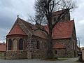
City Church of St. Crucis

Choir and apse

Organ loft


House of Frederick the Great
The building was built by order of King Frederick II, presumably in 1775 as a royal storehouse. The builder was presumably the only construction specialist in town at the time, master bricklayer Wilhelm Blanckenhorn. House Mühlentor 16 was intended to serve as quarters for Frederick II as well as other royal and princely lords who were passing through. Various stables and an official garden originally belonged to the building.

House of Frederick the Great - front view

House of Frederick the Great - rear view


Other structures

- Ziesar Castle with keep and stork tower and the Roman Catholic Chapel of St. Peter and Paul
- Village church Bücknitz , village church Köpernitz
- Residential building of the Ziesar monastery
- Breiter Weg Ziesar (historic market street)
- Bardelebenscher Hof (historic half-timbered house)
- Old fire brigade (Art Nouveau building)
Historical and cultural monuments
- Soviet cemetery of honor from 1949/1950 in the park of the castle with a memorial from 1975/1976 for 31 Soviet soldiers and 14 slave laborers and their children
- Memorial to those who fell in the world wars at the Frauentor
- Monument to Karl Marx on the Breiten Weg
- In 2016, the artist group El Vuelo de Bronce (The Flight of Bronze) on the Breiten Weg designed a total of 16 bronze plates related to Ziesar on the occasion of an international art foundry and sculptor symposium . The artist Anna Franziska Schwarzbach , for example, designed a plate that is reminiscent of the reformer Johannes Aepinus . The casting took place in the studio of the artist Klaus Cenkier, who was involved in the project .
Museums and theaters
- Bishop's residence Burg Ziesar - Museum for Brandenburg Church and Cultural History of the Middle Ages and Burgtheater
- Ziesar local history museum in the area of the outer bailey
- Kruger mill with several exhibitions
Protected areas
In the 1990s, the lowlands of the Fiener Bruch and adjacent plateaus such as the Fläming area were designated as an EU bird sanctuary of Fiener Bruch as part of the Natura 2000 network . The Fiener Bruch is one of only three breeding areas left for the Great Bustard , the heaviest bird capable of flying, which is threatened with extinction in Germany .
A checkerboard flower meadow , the only occurrence east of the Elbe, is designated as a natural monument .
Economy and Infrastructure
economy
- Watermills

The Buckau has been used to drive water mills since the Middle Ages . For this purpose barrages and water mills were installed in several places . The Buckau watermills were primarily used to grind grain. Their economic importance was gradually lost with the extensive shutdown of the mills. However, some systems are still functional and in occasional use. The owl mill, for example, is still used now and then and not commercially as a sawmill . Several Buckau watermills were converted into hydropower plants and have been used to generate electricity ever since. For example, the Eulenmühle and the Kruger Mill feed electricity into the public grid. The Kruger Mill is home to a museum.
traffic
railroad

Since 1897 a narrow-gauge railway of the small railways of the district Jerichow I connected Ziesar with the castle (near Magdeburg) . In 1901 a connection to Wusterwitz (branch from the Brandenburg – Magdeburg line) went into operation, which was extended to Görzke in 1912 . In 1916 the Güsen – Ziesar railroad finally went into operation (see also Kleinbahn-AG in Genthin ). In this context, Ziesar also received a new central station in the east of the city. The narrow-gauge railway was discontinued in 1960, the line to Wusterwitz in 1971. On the line to Görzke there had only been freight traffic since 1973, which was carried out until 1994. Until 1999 there was still passenger traffic to Güsen and goods traffic to a connection in Bücknitz , after which the routes were closed and largely dismantled. On the route to Görzke today there is a cycle path from the motorway junction at Ziesar to Görzke. The buildings of the narrow-gauge train station Ziesar West in the north of the city, the first train station on the line to Wusterwitz, in the north-east and the former central station in the east of the city have been preserved, the facilities of the central station are listed as a historical monument, as is the no longer used locomotive shed in the southern part of the Station area.
Street
Ziesar has been connected to the Prussian road network since 1862. The federal road 107 between Genthin and Wiesenburg / Mark and the state road L 93 Ziesar – Brandenburg an der Havel run through the city.
In 1936, today's A 2 motorway was opened, which leads past the city about three kilometers south. The Buckautal service area is located near the Ziesar junction .
education
- Thomas Müntzer Primary School
- Thomas Müntzer all-day high school, comprehensive school with upper secondary school until 2008
Personalities
sons and daughters of the town
- Johannes Aepinus (around 1499–1553), theologian and church political reformer
- Leberecht Cleinow (1701–1762), pastor at Königsberg Cathedral
- Johann Friedrich Wilhelm Wilberg (1766–1846), educator
- Albert Fischer (1829–1896), Protestant pastor and hymnologist
- Paul Schneider (1863–1946), Privy Councilor of War, farmer and last private owner of Ziesar Castle from 1917 to 1945
- Otto Altenkirch (1875–1945), painter
- Otto Roloff (1886–1941), politician ( DDP ) and administrative officer
- Günther Dietz (1919–2003), painter
- Karl-Heinz Priese (1935–2017), Egyptologist
- Karsten Schwanke (* 1969), meteorologist and television presenter
Personalities associated with the city
- Ludwig Schenk von Neindorf († 1347), Brandenburg bishop, made Ziesar the permanent residence of the diocese
- Johann von Rohr (1579–1624), from 1608 to 1623 official governor in Ziesar
- Johann Friedrich Bollmann (1852–1901), well-known original (Fritze Bollmann). Between 1875 and 1879 he worked temporarily as a barber in Ziesar.
- Wilhelm Kuhnert (1865–1926), painter
- Jens Riechers (* 1964), national rugby player, attended the extended high school in Ziesar and lived in the boarding school for four years
literature
- Winfried Schich : Ziesar. Potsdam-Mittelmark district (25 km south-west Brandenburg adH) . In: Lieselott Enders , Evamaria Engel , Gerd Heinrich , Winfried Schich (eds.): City book Brandenburg and Berlin (= Peter Johanek , Franz-Joseph Post, Klaus Meyer-Schwickerath in the Institute for Comparative Urban History at the University of Münster [ed.]: German City book, handbook of urban history, volume 2). Verlag W. Kohlhammer, Stuttgart / Berlin / Cologne 2000, ISBN 3-17-015388-9 , pp. 569-574.
- Detlev von Olk: Ziesar Castle . In: Palaces and Gardens of the Mark . Issue 86, Berlin 2006.
- Silvia Zimmermann: From the well to the central water supply. History and stories about the water of Ziesar . 1st edition, Treibgut Verlag, Berlin 2008, ISBN 978-3-941175-08-2 .
Web links
- Ziesar in the genealogical directory
- Official website of the historic city of Ziesar
Individual evidence
- ↑ Population in the State of Brandenburg according to municipalities, offices and municipalities not subject to official registration on December 31, 2019 (XLSX file; 223 KB) (updated official population figures) ( help on this ).
- ↑ Sebastian children and Haik Thomas Porada (ed.): Brandenburg an der Havel and surroundings. 2006, p. 281.
- ^ Service portal of the state administration Brandenburg. City of Ziesar
- ↑ Information board : The Alte See , in the area at the Alten See south of the castle, April 2017.
- ↑ Gustav Abb and Gottfried Wentz: The Diocese of Brandenburg . First part, In: Germania sacra , Berlin and Leipzig 1929, Walter de Gruyter, p. 68 f.
- ↑ Ursula Creutz: History of the former monasteries in the Diocese of Berlin in individual representations. Leipzig 1995, ISBN 3-89543-087-0 , p. 191.
- ↑ Dieter Berg (Ed.): Traces of Franciscan History. Chronological outline of the history of the Saxon Franciscan provinces from their beginnings to the present. Werl 1999, p. 49.
- ^ City of Ziesar: Ziesar - A historical city tour , flyer, no date
- ↑ StBA: Changes in the municipalities in Germany, see 2002
- ↑ StBA: Changes in the municipalities in Germany, see 2002
- ^ Historical municipality register of the state of Brandenburg 1875 to 2005. Landkreis Potsdam-Mittelmark . Pp. 30-33
- ↑ Population in the state of Brandenburg from 1991 to 2017 according to independent cities, districts and municipalities , Table 7
- ^ Office for Statistics Berlin-Brandenburg (Ed.): Statistical report AI 7, A II 3, A III 3. Population development and population status in the state of Brandenburg (respective editions of the month of December)
- ^ Result of the local election on May 26, 2019
- ↑ Results of the local elections in 1998 (mayoral elections) for the district of Potsdam-Mittelmark ( Memento of the original from December 1, 2017 in the Internet Archive ) Info: The archive link was inserted automatically and has not yet been checked. Please check the original and archive link according to the instructions and then remove this notice.
- ↑ Brandenburg Local Election Act, Section 73 (1)
- ^ Result of the mayoral election on May 26, 2019
- ↑ Coat of arms information on the service portal of the state administration of Brandenburg
- ^ Karlheinz Blaschke , Gerhard Kehrer, Heinz Machatschek: Lexicon cities and coats of arms of the GDR . Verlag Enzyklopädie, Leipzig 1979, p. 500/501
- ^ Otto Hupp: German coat of arms . Kaffee-Handels-Aktiengesellschaft , Bremen 1925
- ↑ Information board : Open-air gallery , set up on the artwork, May 2019.
- ↑ Part sheet Northwest Protected Areas. (PDF) In: Landkreis Potsdam-Mittelmark landscape framework plan. Office for Environmental and Landscape Planning, archived from the original on August 7, 2011 ; Retrieved October 16, 2013 .
Districts: Bücknitz | Glienecke | Köpernitz - inhabited parts of the municipality: Grebs | Herrenmühle - Residential places: Eulenmühle | Kobser Mill
Cities: Bad Belzig | Beelitz | Bridge | Havelsee | Niemegk | Teltow | Treuenbrietzen | Werder (Havel) | Ziesar
Municipalities: Beetzsee | Beetzseeheide | Bensdorf | Borkheide | Borkwalde | Buckautal | Golzow | Görzke | Trenches | Gross Kreutz (Havel) | Kleinmachnow | Lehnin Monastery | Linthe | Michendorf | Mill flow | Nuthetal | Päwesin | Broken plan | Planetal | Rabenstein / Fläming | Rosenau | Roskov | Schwielowsee | Seddiner See | Stahnsdorf | Wenzlow | Wiesenburg / Mark | Wollin | Wusterwitz