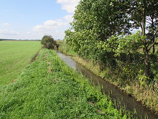
Buckauer main ditch
|
Buckauer Hauptgraben Kobser Bach |
||
|
Buckauer Hauptgraben in the Fiener Bruch |
||
| Data | ||
| Water code | DE : 58724 | |
| location | Potsdam-Mittelmark district , Brandenburg , Germany | |
| River system | Elbe | |
| Drain over | Buckau → Havel → Elbe → North Sea | |
| source | about one kilometer south of Ziesar, 52 ° 15 ′ 1 ″ N , 12 ° 17 ′ 15 ″ E |
|
| muzzle | south of Viesens in the Buckau coordinates: 52 ° 19 ′ 13 ″ N , 12 ° 24 ′ 2 ″ E 52 ° 19 ′ 13 ″ N , 12 ° 24 ′ 2 ″ E
|
|
| length | 14.2 km [1] | |
| Catchment area | 50.24 km² [2] | |
| Right tributaries | Siebbach | |
| Small towns | Ziesar | |
| Communities | Rosenau | |
The Buckauer Hauptgraben , in its upper course Kobser Bach , is a flowing body of water in the Potsdam-Mittelmark district in Brandenburg . It rises south of the small town of Ziesar and flows into the Buckau in the Fiener Bruch .
course
The trench-like developed Kobser Bach rises in a wetland, the Alter See , about one kilometer south of Ziesar. It initially runs in a northerly direction, taking up the water from several melioration ditches. Within the city, he passes Ziesar Castle , which is located directly on its eastern bank. To the north of Ziesar it changes direction and runs for about one kilometer in an easterly direction. This is where the Kobser Mühle is located , a first barrage in the Buckauer main trench. Just below this mill, the flowing water gives off an oxbow of the Kobser Bach, which ends blindly in the Fiener Bruch after about three kilometers. The Buckauer Hauptgraben swings sharply to the north again and takes up the Siebbach to the west of the Bücknitzer Heide shortly after reaching the glacial valley Fiener Bruch, which was formed during the Ice Age . Further weirs and barrages are passed. To the north-west of Bücknitz in the Bruchtal valley, the Buckauer Hauptgraben takes up a section of the Fiener main receiving water that is only referred to as the Hauptgraben and drains to Buckau, and swings again to the east in its course. About 200 meters before the confluence with the Buckau, south of the village of Viesen , the Zitzer Landgraben , also a drainage ditch of the Fiener Bruch, is added. The Buckauer Hauptgraben finally joins the Buckau near the Viesener Mühle . The area of the Buckau main trench including its upper course Kobser Bach is 14.2 kilometers, its catchment area covers a little more than 50 square kilometers. Nine weirs in its course serve to regulate the runoff and water level.
Protected areas
Protected areas in the course of the Kobser Bach and the Buckauer main trench are the protected landscape component of the Alter See south of Ziesar, which is also a protected biotope . To the north of Ziesar, the water flows through the Fiener Bruch bird sanctuary ( SPA area ).
Individual evidence
- ↑ Partial sheet Southwest Surface Waters. In: Landkreis Potsdam-Mittelmark landscape framework plan. Office for Environmental and Landscape Planning, archived from the original on August 7, 2011 ; Retrieved June 7, 2014 .
- ^ Partial sheet Southwest Protected Areas. In: Landkreis Potsdam-Mittelmark landscape framework plan. Office for Environmental and Landscape Planning, archived from the original on August 7, 2011 ; Retrieved June 7, 2014 .

