
Karower plate
| Karower plate | ||
|---|---|---|
 South slope of the Karower Platte near Viesen |
||
| Highest peak | Gollwitzer Berg ( 85.9 m above sea level ) | |
| location | District of Potsdam-Mittelmark and Brandenburg an der Havel in Brandenburg and District of Jerichower Land in Saxony-Anhalt ( Germany ) | |
|
||
| Coordinates | 52 ° 21 ′ N , 12 ° 19 ′ E | |
| Type | Ground and terminal moraine , sander | |
| rock | Boulder clay , boulder clay , sand and gravel | |
| Age of the rock | Saale and Weichsel ice age | |
| surface | 74 km² | |

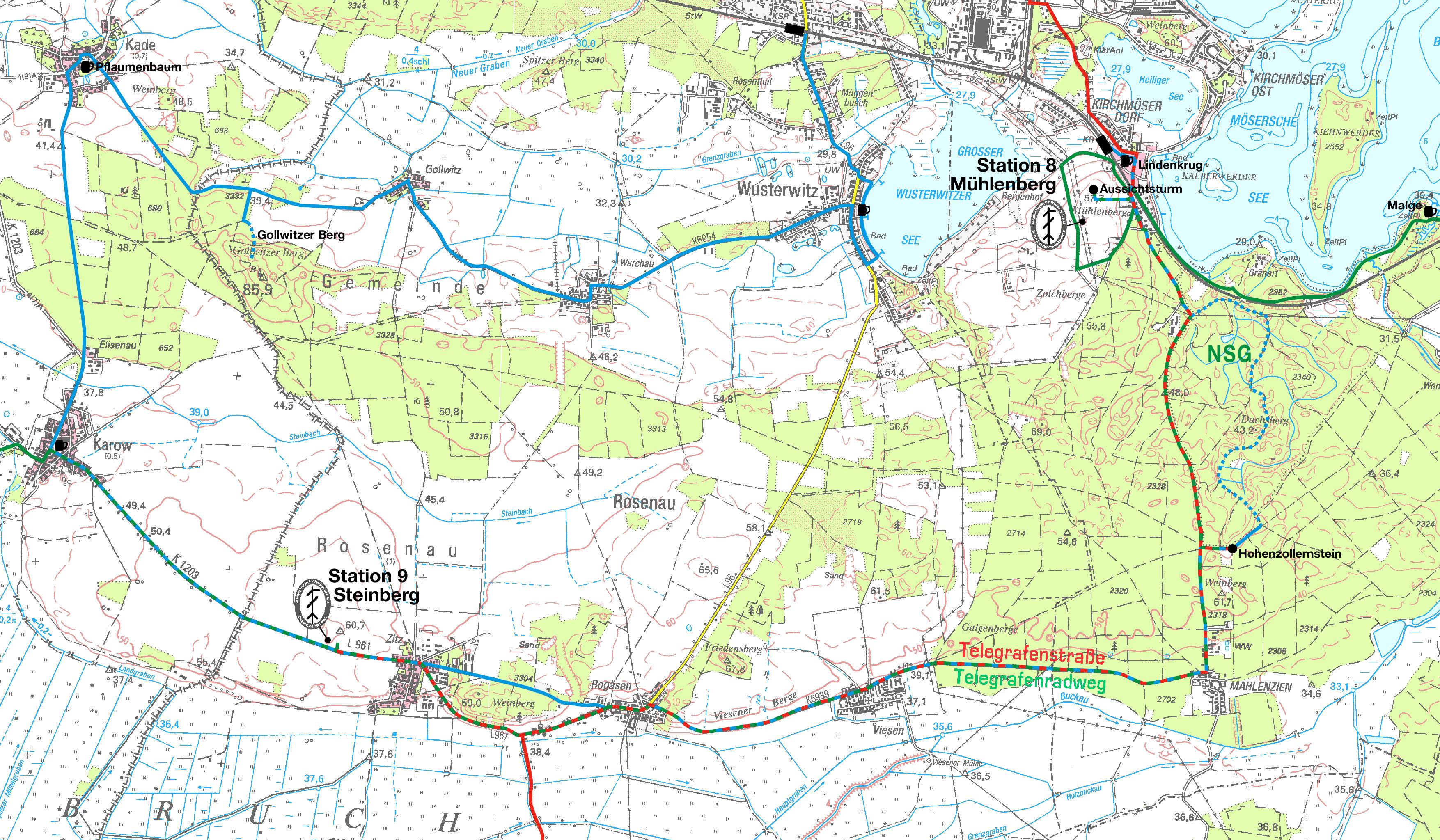
The Karower Platte is a plateau formed during the Ice Age in the states of Brandenburg and Saxony-Anhalt .
geography

The Weichselian time overprinted high surface of the plate has a Karower Saalian Altmoränenkern . It was formed by ice advancing from Scandinavia to Central Europe on the main ice edge of the Brandenburg phase . It is located southwest of the city of Brandenburg an der Havel and, together with the Zauche to the east, forms a row of plates that is divided in two by a small breakthrough in the Baruther glacial valley . In this breakthrough some running in Fläming sprung rivers such as the Plane , Temnitz and Buckau from the Baruth glacial valley of Havel to. The Karower Platte rises on average about 30 meters above the flat surrounding area. The highest elevation is the 85.9 meter high Gollwitzer Berg in the western area , formed at the ice edge location 1 a . The plate is bounded in the west and south by the Fiener Bruch , which is part of the glacial valley , in the east by the breakthrough and in the north by valley sand low areas such as the Wusterwitz basin. In the easternmost area of the plate one can make out the typical glacial series with a rear ground moraine , a domed terminal moraine , the Mahlenziener Sander and the glacial valley. In the Karower Platte area, different types of brown earth dominate the soil . An exception is the sand, which has sand-brown podsol / podsol soils . The only natural flowing water of the plateaus is the Steinbach , which flows westwards, flows into the rift system of the Fiener Bruch and is drained via the Fiener main receiving water to the Elbe-Havel Canal .
Localities
The Karower Platte plateau itself is not populated. Localities can only be found in their peripheral areas. The city of Brandenburg includes Kirchmöser in the northeast and Mahlenzien on the southern slope . More Brandenburg villages on the northern slope Wusterwitz and to Rosenau belonging Warchau and Gollwitz . On the southern slope, Viesen , Rogäsen and Zitz are also districts of the Rosenau community. In Saxony-Anhalt to the city are Jerichow belonging Kade on the north and the eponymous Karow on the southern branch.
Surveys
- The Gollwitzer Berg near the village of Gollwitz, which belongs to Rosenau, is the highest point on the Karower Platte at 85.9 meters.
- The vineyard immediately east of Zitz is 69 meters high.
- The 67.8 meter high Friedensberg is an elevation near the village of Rogäsen.
- Also an old vineyard, which is 61.7 meters high, is located immediately north of Mahlenziens.
- The Steinberg west of the village of Zitz has a height of 60.7 meters.
- The Mühlenberg with 60.6 meters is located near Kirchmöser Dorf directly across the Berlin - Magdeburg railway line.
- A vineyard near Kade is 48.5 meters high.
- The 43.2 meter high Dachsberg is located in the Gränert nature reserve in the Neustadt forest of the city of Brandenburg and north of the Mahlenziener Weinberg.
Protected areas
In Brandenburg, the eastern area of Karower plate is protected landscape Brandenburg forest and lake area. The eastern part of this landscape protection area to Buckau is shown separately as a nature reserve Gränert and as FFH area Gränert. Southern areas are covered by the Fiener Bruch bird sanctuary ( SPA area ). "Wachauer Mühle" has been declared a protected part of the landscape . There are also some protected biotopes .
Flora and fauna
Most of the hilly plateaus are used for agriculture. In addition, large areas, for example around the Gollwitzer Berg and in the east in the city of Brandenburg, are predominantly overgrown with monocultural pine forests. An exception is the nature reserve Gränert. There is a species and structurally rich mixed deciduous forest , where there beside pine and beech trees , oaks , sessile oak , birch , Common ash trees , poplars , rowan , bird cherry and red alder are. Also suitable valerian and silver grass before. Sea eagles and ospreys breed in the forest areas . Other birds are black woodpecker , middle woodpecker and bittern . Other species such as badger , mourning cloak , slow worm , common toad and rhinoceros beetle are also native.
Individual evidence
- ↑ Sebastian children and Haik Thomas Porada (ed.): Brandenburg an der Havel and surroundings. 2006, p. 4, fig. 2, p. 6, p. 279, p. 298 fig. 72.
- ↑ Sebastian children and Haik Thomas Porada (ed.): Brandenburg an der Havel and surroundings. 2006, p. 2, fig. 1.
- ↑ Sebastian children and Haik Thomas Porada (ed.): Brandenburg an der Havel and surroundings. 2006, p. 11.
- ↑ Map of the Karower Platte area . Accessed June 15, 2014.
- ↑ Part sheet Northwest Protected Areas. In: Landkreis Potsdam-Mittelmark landscape framework plan. Office for Environmental and Landscape Planning, archived from the original on August 7, 2011 ; Retrieved October 16, 2013 .
- ↑ Brandenburg an der Havel Flora Fauna Habitat (FFH) areas . Accessed June 7, 2014.
- ^ Brandenburg an der Havel nature reserves in the city area . Accessed June 7, 2014.
- ↑ NABU Foundation for National Natural Heritage: Gränert Brandenburg an der Havel , as of January 24, 2014.
- ↑ Sebastian children and Haik Thomas Porada (ed.): Brandenburg an der Havel and surroundings. 2006, p. 284 ff.