Steinbach (Karower Landgraben)
| Steinbach | ||
|
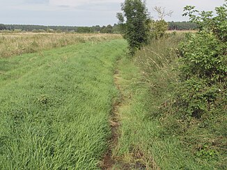
Upper course of the Steinbach in the Karower Platte |
||
| Data | ||
| Water code | DE : 5874888 | |
| location | Potsdam-Mittelmark district , Brandenburg and Jerichower Land district , Saxony-Anhalt Germany | |
| River system | Elbe | |
| Drain over | Karower Landgraben → Fiener main waterway → Elbe-Havel Canal → Havel → Elbe → North Sea | |
| source | on the Karower Platte between Rogäsen and Warchau 52 ° 20 ′ 40 ″ N , 12 ° 21 ′ 22 ″ E |
|
| muzzle | Northwest of Karow in the Karower Landgraben Coordinates: 52 ° 21 '33 " N , 12 ° 14' 2" E 52 ° 21 '33 " N , 12 ° 14' 2" E
|
|
| length | 9.4 km | |
| Small towns | Jerichow | |
| Communities | Rosenau | |
The Steinbach is a brook that rises in the west of Brandenburg , in the district of Potsdam-Mittelmark on the Karower Platte and flows west in Fiener Bruch to Saxony-Anhalt , in the district of Jerichower Land . There it flows into the Karower Landgraben whose water over the Fiener main outfall and the Elbe-Havel channel of Havel run.
course
The almost nine and a half kilometer long brook has its source relatively centrally on the Karower Platte between the villages of Warchau in the north and Rogäsen in the south. The Steinbach is the only natural flowing water in the ridge. It initially flows in a direct westerly direction. At the level of the village of Zitz , the brook swings slightly to the northwest and flows in a shallow valley south of the Gollwitzer Berg . Immediately at Karow , the Steinbach leaves the Karower Platte and reaches the Fiener Bruch , which is part of the Baruther glacial valley . Here is the only bridge structure in the course, a road bridge for the district road 1203. In the Fiener Bruch the bed of the brook is built like a trench. Two to three kilometers northwest of Karow, the Steinbach flows into the Karower Landgraben. It flows over a long distance through the European bird sanctuary Fiener Bruch ( SPA area ).
Individual evidence
- ↑ River directory gewnet25 (Version 4.0, April 24, 2014) from the Ministry for Rural Development, Environment and Agriculture of the State of Brandenburg, accessed on May 4, 2015.
- ^ Partial sheet Northwest Protected Areas (PDF; 5.24 MB) ( Memento from October 12, 2013 in the Internet Archive ), Landkreis Potsdam-Mittelmark landscape framework plan, office for environmental and landscape planning.
