
Brora (river)
| Brora | ||
 |
||
| Data | ||
| location | Scotland | |
| River system | Brora | |
| source | Confluence of three streams north of Dalnessie 58 ° 8 ′ 8 ″ N , 4 ° 19 ′ 40 ″ W |
|
| Source height | 239 m | |
| muzzle | At Brora in the Moray Firth Coordinates: 58 ° 0 ′ 35 " N , 3 ° 50 ′ 44" W 58 ° 0 ′ 35 " N , 3 ° 50 ′ 44" W. |
|
| Mouth height | 0 m | |
| Height difference | 239 m | |
| Bottom slope | 5.7 ‰ | |
| length | 42 km [1] | |
| Flowing lakes | Loch Brora | |
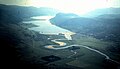
The Brora is a river in the Scottish Council Area Highland . It is created by the confluence of three streams at a height of 239 m a few kilometers north of Dalnessie in the traditional Scottish county of Sutherland . The source rivers arise at heights of 460 to 490 m above sea level. From there it flows 42 km in a south-easterly direction. It flows through all three basins of Loch Brora over a length of seven kilometers . Finally the Brora flows into the Moray Firth at Brora .
The Brora has historically been considered to be one of the best rivers for trout and salmon fishing in Scotland. In Loch Brora, the Duke of Sutherland established a salmon farm at the end of the 19th century. In 1873 1,105,000 eggs were collected there.

Railway bridge over the Brora
Loch Brora

Mouth of the Brora


Web links
Individual evidence
- ↑ a b Brora. In: Francis H. Groome: Ordnance Gazetteer of Scotland: A Survey of Scottish Topography, Statistical, Biographical and Historical. Volume 1: (A - Coru). Thomas C. Jack, Grange Publishing Works, Edinburgh et al. 1882, p. 193.
- ^ Brora, River. In: David Munro, Bruce Gittings: Scotland. An Encyclopedia of Places & Landscapes. Collins et al., Glasgow 2006, ISBN 0-00-472466-6 .