Buariki (Tarawa)
| Buariki | ||
|---|---|---|
| Waters | Pacific Ocean | |
| Archipelago | Gilbert Islands | |
| Geographical location | 1 ° 37 ′ N , 172 ° 57 ′ E | |
|
|
||
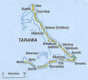
Buariki is an island at the northern end of the Tarawa Atoll in the Gilbert Islands of the island state of Kiribati in the Pacific Ocean . The island is known as the main site of the Battle of the Gilbert Islands in World War II .
geography
Buariki is a motu on the "mast", the northern arm of the Tarawa Atoll. It is 31 km to the main town of Bairiki in South Tarawa and 60 km to the neighboring atoll of Marakei . The island is elongated, directly connected to Tearinibai in the south and borders in the north on the northern tip of the atoll at Naa . The island forms a triangle with a sharp hook to the interior of the lagoon in the west. The main town of the same name is also located on this corner, while extensive coconut plantations grow in the hinterland in the east . At the north end, very narrow strips of islands connect to Naa. There is a road to the south that connects the islands.
history
During World War II, the final battle of the Tarawa Campaign took place here on November 26, 1943 , when the US 2nd Battalion 6th Marines fought out the Battle of Buariki . The entire surviving Japanese force of 156 men, who had fled from Betio and trapped in Buariki, fought to the death. The Marines lost 34 men and wounded 56 people.
Individual evidence
- ↑ North Tarawa Island Report 2012 . Government of Kiribati.
- ↑ Buariki at geonames.org (2020-05-23)

