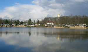
Buchhorner See
| Buchhorner See | |||||||||
|---|---|---|---|---|---|---|---|---|---|
| The Buchhorner See. In the background the Buchhorn landmark, the water tower | |||||||||
|
|||||||||
|
|
|||||||||
| Coordinates | 49 ° 9 '15 " N , 9 ° 30' 6" E | ||||||||
| Data on the structure | |||||||||
| Height of the barrier structure : | 5.0 m | ||||||||
| Crown length: | 140 m | ||||||||
| Crown width: | 3 m | ||||||||
| Base width: | 11 m | ||||||||
| Data on the reservoir | |||||||||
| Altitude (at congestion destination ) | 377 m above sea level NN | ||||||||
| Water surface | 2.5 ha | ||||||||
| Reservoir length | 180 m | ||||||||
| Reservoir width | 150 m | ||||||||
The Buchhorner See is a lake in the district of Pfedelbacher Buchhorn in Hohenlohekreis , Baden-Württemberg . It does not have an above-ground inflow, but feeds itself from groundwater from the forest area above to Gleichen . It has an area of 25,000 m², its water depth is up to 2.50 m and it lies at an altitude of 377 m above sea level. NN . The Pfedelbach rises from the lake , the water of which used to drive a mill in Pfedelbach , about 2 km away. The lake is inhabited by a large number of water birds, and when it is frosty it serves as an ice rink.
history
A document from 1473 shows the sale of goods including the lake in Buchhorn by Götz von Adelsheim to Hohenlohe . In the 1573 inventory book, the 9 acre lake is already owned by Michael von Olnhausen. The property, noted as the inheritance of those von Olnhausen, was still surrounded by a wall in 1745. The rest of the Buchhorn was opposite the point where the Pfedelbach flows out of the lake; it was inhabited by wealthy farmers. The male descendants of the noble farming family von Olnhausen now live in Frankfurt am Main. In 1847 the Buchhorner See became the property of the Oesterlein-Leng family. On September 21, 1949 the dam of the Buchhorn lake broke. The water masses streamed through a 2 m wide and deep crack and caused considerable damage on their way across meadows, through barns and through house cellars. The first campsites were built around the Buchhorner See in 1957. Today there are three campsites on its shore, and it has increasingly become a local recreation area . To the northeast of the lake, the municipality of Pfedelbach built the Buchhorn landmark in 1965 , the 38.5 m high water tower . On June 29, 1989, the Pfedelbach community acquired the entire lake area. The municipality rehabilitated the lake in 2004. After the water had been drained and fished, 10,000 m³ of mud was dredged and spread onto the surrounding fields. As a result, the lake became up to one meter deeper in places.
geology
The Buchhorner See lies on the silica sandstone plateau ( Hassberge formation ) in the northern parts of the Mainhardt Forest .
literature
- Gerhard Taddey (Red.): Pfedelbach 1037–1987. From past and present (= research from Württembergisch-Franken. Vol. 30). Published by the Pfedelbach community. Thorbecke et al., Sigmaringen et al. 1987, ISBN 3-921429-30-7 .
Individual evidence
- ↑ Website of the campsite (accessed on November 29, 2009)
- ↑ [1] (accessed November 29, 2009)


