Waldsberg Castle (Krumbach)
| Waldsberg Castle | ||
|---|---|---|
|
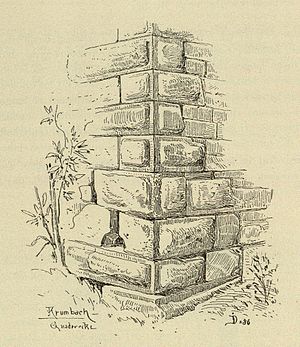
South-eastern hump square corner of the tower |
||
| Creation time : | 13th Century | |
| Castle type : | Höhenburg, spur location | |
| Conservation status: | The ruins, the masonry of the tower and the curtain wall have been preserved | |
| Construction: | Ashlar masonry | |
| Place: | Sauldorf - Krumbach | |
| Geographical location | 47 ° 57 '37.1 " N , 9 ° 2' 27.7" E | |
| Height: | 645 m above sea level NHN | |
|
|
||
The Burgwald mountain is the ruin of a Spur castle on the southwestern outskirts of Krumbach , in the municipality of Sauldorf in the district of Sigmaringen in Baden-Württemberg .
history
The castle "Waltsberg", built in the 13th century, was first mentioned in 1303, when Burkhard von Waldsberg pledged the castle acquired from the Bishop of Constance to Heinrich and Albrecht von Heudorf . The von Waldsberg family was only mentioned in 1303 and 1324. After the castle was mortgaged again in 1328, it and the rulership changed hands. In 1788 all the buildings in the outer bailey, extensions and farm buildings were still preserved; they were demolished by the middle of the 19th century. The castle last consisted of an old castle, the current ruin, and a new house, probably located south of the tower.
description
The two-part castle ruins are located at around 645 m above sea level. NN height on the western edge of a plateau advancing north into the valley of the Krummbach . The castle probably had a total area of 0.6 hectares, the current ruins still cover around 600 square meters.
The ruin, which is located on a rock ledge protruding to the west, still shows the square remains of the curtain wall , of which only the east side shows rising masonry. The southeast corner of the curtain wall is a square tower that is up to six meters high and has a side length of eight meters, a wall thickness of 2.5 meters and an interior space of 10 square meters. The west side of the tower ruin is badly damaged. This tower consists of warehouse-like limestone ashlar masonry with humpback blocks at the corners of buildings. Remnants of a window have been preserved on the south wall of the tower. The north-facing, up to two meters thick curtain wall connects to its northeast corner; it has been preserved up to a height of 2.5 meters, and after 15 meters before the northern steep slope turns at right angles to the west. 6.4 meters before the northeast corner, the curtain wall bends in a slight angle to the west. To the east of the curtain wall there was presumably a neck ditch , to the east and south-east of this was the area of the outer bailey with the castle's farm buildings.
literature
- Hans-Wilhelm Heine : Studies on weir systems between the young Danube and western Lake Constance . In: Landesdenkmalamt Baden-Württemberg (Hrsg.): Research and reports on the archeology of the Middle Ages in Baden-Württemberg. Volume 5 . Stuttgart 1978, ISSN 0178-3262 , pp. 93 and 160.
Web links
- Entry on Waldsberg in the private database "Alle Burgen".
Individual evidence
- ↑ Waldsberg at leo-bw.de
- ^ Hans-Wilhelm Heine: Studies on weir systems between the young Danube and western Lake Constance , p. 93
- ^ Source description: Hans-Wilhelm Heine: Studies on weir systems between the young Danube and western Lake Constance , pp. 93 and 160


