
Rotenfels castle ruins
| Rotenfels castle ruins | ||
|---|---|---|
 Wall sections of the Rotenfels castle ruins |
||
| Alternative name (s): | Alt-Waxenberg ruins, high-rise building | |
| Creation time : | 1136 | |
| Castle type : | Hilltop castle | |
| Conservation status: | ruin | |
| Place: | Herzogsdorf | |
| Geographical location | 48 ° 26 '52 " N , 14 ° 10' 9" E | |
| Height: | 740 m above sea level A. | |
|
||

The Rotenfels castle ruins , also known as Alt-Waxenberg , are the ruins of a hilltop castle at 740 m above sea level. A. near Herzogsdorf in the Mühlviertel in Upper Austria . The walls can be reached by following the path leading straight into the forest from the Buchholz 45 farm after approx. 700 m. The castle was built around 1136, abandoned after around 160 years and fell into disrepair over time.
Surname
The castle name Rotenfels is a site name. The joint was formed from mhd . rôt (= red) and mhd. vels (= rock) . In the Middle Ages, the common dative naming of places resulted in the contracted "(to) red rock", which could indicate at least one rock of reddish (e.g. iron-containing) rock.
The castle also represented the highest point of the Waxenberg rule, hence the name skyscraper , under which it is now common among the population.
history
| year | Documented name |
|---|---|
| 1146 | Rotenvels |
| 1206 | Rotinvels |
| 1250 | Rotenvels |
| 1499 | Rotenfelß |
It is not known who built the castle. The first mention was around 1136, when a Colo de Rotenvelse was mentioned as the owner. The Rotenfels were Ministeriale of the Wilhering-Wachsenberger and owned the castle for around 160 years. According to Colo, Marquart (1160), a Leutold (1210), Hermann (1237), Wernhart (1250), Konrad (1297), who was also an abbot in Wilhering and a Wernhart (1309-1328), are named as owners. Alber was mentioned as the last owner of the facility around 1356. After his death the castle fell into disrepair.
Around 1291, Waxenberg Castle was built just five kilometers away from the Wilheringers. Around 1291 the district court of Rotenfels was probably transferred to Waxenberg. Some historians believe that Rotenfels as the seat of power was the predecessor of Waxenberg, hence the name Alt-Waxenberg. Others think that the castle was a flank protection for Waxenberg, like St. Veit too .
- Rotenfels castle ruins

Rotenfels castle ruins: rock wall
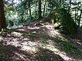
Rotenfels castle ruins: Burgplatz

Rotenfels castle ruins: remains of the wall
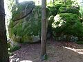
Rotenfels castle ruins: granite blocks


description
The castle lay on a ridge that slopes steeply to the north and south. The castle was only accessible from the east. The rock ridge is now called Buchholz or Burgholz. On the north side the wall drops steeply, one could get the impression that this wall has been scarred .
Today there is only masonry left, which is around 2.5 m thick. The core is made of cast masonry, on the outside there are carefully hewn cuboids that were connected with a very hard mortar. At the highest point the wall now reaches more than eight meters. The system was around 86 meters long and up to eight meters wide. The wall is of Romanesque origin. Huge granite blocks can be found on the way to the ruins .
literature
- Norbert Grabherr : Castles and palaces in Upper Austria. A guide for castle hikers and friends of home. 3. Edition. Oberösterreichischer Landesverlag, Linz 1976, ISBN 3-85214-157-5 .
- Oskar Hille: Castles and Palaces of Upper Austria , Wilhelm Ennsthaler, 2nd edition, Steyr 1992, ISBN 3850683230 .
- Konrad Schiffmann : Historical place name lexicon of the state of Upper Austria. 3 volumes. Jos. Feichtingers Erben , Linz 1935 (supplementary volume published by the Oldenbourg publishing house, Munich / Berlin 1940).
Web links
- Rotenfels at burgenkunde.at.