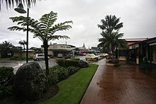
Burnt pine
| Burnt pine | ||
|---|---|---|
|
|
||
| Coordinates | 29 ° 2 ′ S , 167 ° 57 ′ E | |
| Basic data | ||
| Country | Norfolk Island | |
| ISO 3166-2 | NF | |
| height | 117 m | |
| Residents | 180 (2007) | |
| founding | 1943 | |
Burnt Pine ( norfuk : Ban Pain ) is the largest site on Norfolk Island in the Pacific Ocean .
The settlement with an estimated 180 inhabitants in 2007 is the commercial center of the island . There are a number of shops and cafes in the town center.
geography
The place is located on an east-west oriented ridge of volcanic rock , about 117 meters above sea level . The upper reaches of Cascade Creek, Broken Bridge Creek (north side) and Watermill Creek (south side) flow just below the ridge.
The island's capital, Kingston , is about three kilometers south of the town. There is a school on the eastern edge of Burnt Pine. About two kilometers north of the village are the ruins of the old whaling station.
history
In 1844 and 1904 are on two cards at the point where today the place is at, agricultural establishments exist. The impetus for the establishment of the place came in 1942 during the Pacific War, when the construction of a military airfield began (now the Norfolk Island International Airport ). This meant the destruction of the prisoner-planted Pine Avenue for the east-west runway. Between 1943 and 1944 the army produced the "Burnt Pine News" - the newspaper title was the first use of the place name.
At the end of the war, a number of shops and a new hospital stood around the intersection of Taylors Road and Grassy Road. From 1946 the increasing air traffic led to a considerable increase in tourism . In 1952 a new hospital was built in the village. In the 1960s, the city experienced a sharp increase in tourism, and the current name Burnt Pine developed .
Attractions
Burnt pine
- Norfolk Island Bowling Club (1939)
- Rawson Hall (1946)
- South Pacific Hotel
- Lions Park Sports Grounds and Grandstand (1974)
- Foodland Mall (1980)
- The Bicentennial Complex (1988)
- Bounty Square and Ship Monument (2000)
Middlegate
- Bounty Folk Museum (1980)
- Governor's Lodge Resort (1998)
- Fletcher's Mutiny Cyclorama (2002)
- Queen Victoria Gardens (2009)
Individual evidence
- ↑ N. Diatloff: Norfolk Island Hydrology Study . Norfolk Island Administration, Kingston 2007, p. 5.
- ↑ Weather and Climate: Burnt Pine, Norfolk Island, average monthly, Rainfall (millimeter), Sunshine, Temperatures (celsius), Sunshine, Humidity, Water Temperature, Wind Speed. Retrieved August 31, 2017 .
- ↑ Wayback Machine. (No longer available online.) February 11, 2005, archived from the original on February 11, 2005 ; accessed on August 31, 2017 . Info: The archive link was inserted automatically and has not yet been checked. Please check the original and archive link according to the instructions and then remove this notice.
- ↑ Travel Information. Retrieved August 31, 2017 (UK English).

