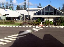
Norfolk Island International Airport
| Norfolk Island International Airport | |
|---|---|

|
|
| Characteristics | |
| ICAO code | YSNF |
| IATA code | NLK |
| Coordinates | |
| Height above MSL | 113 m (371 ft ) |
| Transport links | |
| Distance from the city center | 3.5 km northwest of Kingston |
| Basic data | |
| opening | December 25, 1942 |
| operator | Norfolk Island Regional Council |
| surface | 120 ha |
| Terminals | 1 |
| Passengers | 60,686 (2018) |
| Flight movements |
464 (2018) |
| Runways | |
| 11/29 | 1890 m × 45 m asphalt |
| 04/22 | 1435 m × 30 m asphalt |
Norfolk Island International Airport ( German International Airport of Norfolk Island ) is the international and only airport of Norfolk Island , an Australian outlying area . It is located about 3.5 kilometers northwest of the capital Kingston .
The airport is operated by the Norfolk Island Regional Council.
history
The airfield was built by the United States Armed Forces during World War II as a measure against feared Japanese operations in the South Pacific . Because there was not enough flat terrain on the island, heavy equipment had to be used to remove hills and fill in valleys. Steel mesh mats ensured that the floor was sufficiently stable.
At first the airfield was used for military purposes, later mainly as a stopover on trips to Australia , New Caledonia , New Zealand and the Solomon Islands . After the end of the war, the Royal New Zealand Air Force , which had meanwhile taken over the airfield , withdrew its forces from the island and handed the airfield over to civilian administration in 1948.
Facilities
The airport has two asphalt runways. The only terminal has four check-in counters , security facilities, immigration and customs authorities, baggage claim belts and a café. Aircraft up to the size of an Airbus A320 can be handled.
There is a small cargo terminal next to the passenger terminal.
Airlines and destinations
As of October 2015, the airport is only served by Air New Zealand from Auckland , Brisbane and Sydney . Norfolk Air ceased operations in 2012.
Web links
- Airport data on World Aero Data ( 2006 )
- Airport data Norfolk Island Airport in the Aviation Safety Network (English)
- Norfolk Island International Airport. Official website of the airport.
- Aeronautical map for Norfolk International Airport on SkyVector.com
Individual evidence
- ↑ a b c d Airport. In: Services. Norfolk Island Regional Council, accessed October 14, 2017 .
- ↑ a b Airport Traffic Data 1985 to 2018. (XLSX; 1.02 MB) In: Airport traffic data. Bureau of Infrastructure, Transport and Regional Economics (BITRE), accessed June 29, 2019 .
- ↑ a b c Aerodrome & Procedure Charts. Norfolk Island (YSNF) - Aerodrome Chart. In: Aeronautical Information Package. Airservices Australia, accessed on October 14, 2017 (with links to the current charts).
- ^ Government Services on Norfolk Island. In: Territories of Australia. Australian Government - Department of Infrastructure, Transport, Cities and Regional Development, accessed June 29, 2019 .
- ↑ James A. Michener 's short story Mutiny from the Tales of the South Pacific collection, roughly and fictionally portrays the decision making process of cutting down obstructing pine trees.
- ↑ Oliver A. Gillespie: The Pacific . Ed .: Howard Karl Kippenberger. War History Branch, Department of Internal Affairs , Wellington, New Zealand 1952, Chapter 11 - The Smaller Garrisons: III. Norfolk Island, S. 301-306 ( available online in the New Zealand Electronic Text Collection (NZETC)).
- ^ Philip Hayward: Bounty Chords - Music, Dance and Cultural Heritage on Norfolk and Pitcairn Islands . Libbey, London 2006, ISBN 0-86196-678-3 , pp. 113 (English, limited preview in Google Book search).
- ^ Aeronautical Information Package. En Route Supplement Australia (ERSA) - Norfolk Island - FAC. Airservices Australia, accessed on October 14, 2017 (English, the ERSA link leads to an airport list with the current links to the Aerodrome and Facility Directory [FAC] and Runway Distance Supplement [RDS]).