
Cote d'Opale

The Côte d'Opale ( Opal Coast ) is the French coastal strip of the English Channel from Dunkerque in the north to the mouth of the Somme in the south. The name is derived from the blue-green color of the water.
It is characterized by an alternation of long sandy beaches with the mouth of several rivers and the cliffs of the chalk coast. Especially in the south z. T. high dune belts . The coast is in the area of influence of the tide . While the sea surfs right up to the dunes when the tide is high, sand flats up to several hundred meters wide form at low tide. In the estuaries of the Somme , Authie and Canche rivers , large salt marshes are exposed at low tide . On the chalk coast, the layers of chalk emerge from the water. There the beach is also formed by flint stones that have been weathered from the layers of chalk. The most important landmarks in the area of the chalk coast are Cape Blanc-Nez south of Calais and Cape Gris-Nez further south .
There are numerous seaside resorts along the Opal Coast, some of which have developed from fishing villages and others have been newly planned, such as Stella Plage. The largest coastal towns from north to south are:
- Dunkirk
- Gravelines
- Calais
- Boulogne-sur-Mer
- Le Touquet , including Pearl of the Côte d'Opale called
- Berck
- Saint-Valery-sur-Somme on the Somme estuary
Coordinates: 50 ° 30 ′ 0 ″ N , 1 ° 35 ′ 0 ″ E
gallery
The coast at
Cape Gris-Nez,
... at Calais,
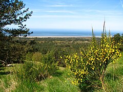
… View from
Mont St Frieux
... and
Cape Blanc-Nez.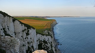
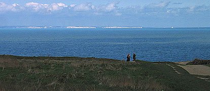
View from Cap Blanc-Nez over the Bay of Wissant to
Cap Gris-Nez

_1.jpg)

.JPG)
