Authie (river)
| Authie | ||
|
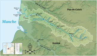
Catchment area of the Authie |
||
| Data | ||
| Water code | FR : E5500570 | |
| location | France , Hauts-de-France region | |
| River system | Authie | |
| source | in the municipality of Coigneux 50 ° 8 ′ 33 ″ N , 2 ° 33 ′ 25 ″ E |
|
| Source height | approx. 122 m | |
| muzzle | between Fort-Mahon-Plage and Berck in the English Channel Coordinates: 50 ° 24 ′ 8 ″ N , 1 ° 32 ′ 39 ″ E 50 ° 24 ′ 8 ″ N , 1 ° 32 ′ 39 ″ E |
|
| Mouth height | 0 m | |
| Height difference | approx. 122 m | |
| Bottom slope | approx. 1.1 ‰ | |
| length | 108 km | |
| Catchment area | 1156 km² | |
| Left tributaries | Gézincourtoise | |
| Right tributaries | Quilliene , Grouche , Warnette, Fliers | |
| Small towns | Doullens , Berck | |
|
The Authie at Maintenay |
||
The Authie is a river in France that runs in the Hauts-de-France region and, especially in the lower reaches, also marks the border between these two regions over longer stretches. It rises in the border area of the two municipalities of Coigneux and Souastre at a height of about 122 meters and generally drains north-west through predominantly agricultural areas. The valley of the river is home to a diverse flora and fauna, but also passes many places with historic castles and monasteries. In the last twelve kilometers of the river forms an estuary , located between the towns of Fort-Mahon-Plage and Berck for Bay Baie de l'Authie expands where the Authie finally to a total length of 108 kilometers in the English Channel opens. On its way, the river crosses the Somme and Pas-de-Calais departments .
Places on the river
- Coigneux
- Authie
- Doullens
- Auxi-le-Château
- Dompierre-sur-Authie
- Nampont
- Groffliers
- Fort Mahon Plague
- Berck
Attractions
- Valloires Monastery , former Cistercian abbey

