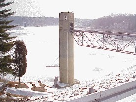
Cagles Mill Lake
| Cagles Mill Lake | |||||||
|---|---|---|---|---|---|---|---|
|
|||||||
|
|
|||||||
| Coordinates | 39 ° 29 ′ 13 ″ N , 86 ° 54 ′ 58 ″ W | ||||||
| Data on the structure | |||||||
| Lock type: | dam | ||||||
| Construction time: | 1948-1952 | ||||||
| Height of the barrier structure : | 45.7 m | ||||||
| Height of the structure crown: | 222.5 m | ||||||
| Crown length: | 274 m | ||||||
| Base width: | 192 m | ||||||
| Operator: | United States Army Corps of Engineers | ||||||
| Data on the reservoir | |||||||
| Altitude (at congestion destination ) | 194 m | ||||||
| Water surface | 5.7 km² | ||||||
| Catchment area | 764 km² | ||||||
The Cagles Mill Lake (also Cataract Lake ) is a reservoir on Mill Creek in Indiana and is primarily used for flood protection . The 1948–1952 built by the United States Army Corps of Engineers earth and stone dam is located on the lower reaches of the river in Putnam County , about four and a half kilometers before the confluence of Mill Creeks with Big Walnut Creek . The greater southeast part of the lake is part of Owen County .
With normal traffic jam - the lake level is 193.9 m above sea level in winter and 194.3 m in summer - an area of 5.7 km². In the event of flooding, the water level can rise by over 20 meters, and the flooding of adjacent valleys means the lake has an area more than three times as large. A narrow point only about 100 m wide, called "Middle Narrows", divides the reservoir into two basins. A bridge leads Indiana State Road 42 over the narrow southern part of the lake. Nearby is the only island in the water, Ernie Pyle Island .
The lake is named after an old mill just below the dam. This burned down in 1975, the weir system is still preserved. The name Cataract Lake, which is also used, is derived from the Cataract Falls , which are located near the mouth of the Mill Creek into the lake.
At the reservoir is a state recreation area, the Lieber State Recreation Area .

