Mill Creek (Eel River, Indiana)
|
Mill Creek Eel River |
||
|
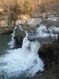
Mill Creek at Cataract Falls |
||
| Data | ||
| Water code | US : 439158 | |
| location | Indiana (USA) | |
| River system | Mississippi River | |
| Drain over | Eel River → White River → Wabash River → Ohio River → Mississippi River → Gulf of Mexico | |
| source | at Danville in Hendricks County 39 ° 46 ′ 23 ″ N , 86 ° 35 ′ 44 ″ W |
|
| Association with |
Big Walnut Creek to Eel River Coordinates: 39 ° 29 ′ 40 " N , 86 ° 57 ′ 5" W 39 ° 29 ′ 40 " N , 86 ° 57 ′ 5" W |
|
| Mouth height |
176 m
|
|
| length | approx. 75 km | |
| Catchment area | 1001 km² | |
| Right tributaries | Deer Creek | |
| Reservoirs flowed through | Cagles Mill Lake | |
The Mill Creek ( English for "Mühlbach") is the approximately 70 km long left source river of the Eel River in the US state of Indiana .
The river has its origin in Marion Township , Hendricks County , west of the city of Danville . The still small stream flows south through the county, in the town of Stilesville it joins other small streams, including the East Fork Mill Creek . In the middle reaches the Mill Creek has been straightened and flows in a canal-like bed, the Mill Creek Ditch . Only a few oxbow lakes and the borders of Putnam and Hendricks as well as Putnam and Morgan Counties following the original stream bed are evidence of the old course of the water . After the Interstate 70 flyover, Mill Creek flows southwest and eventually through the southeast corner of Putnam County.
In Owen County , the small river reaches hilly terrain and thus a natural river bed again. After a turn to the west or northwest, the Mill Creek flows over the Cataract Falls . These waterfalls consist of two levels - the six-meter-high Upper Falls and the five-meter high Lower Falls - and are Indiana's largest falls in terms of the amount of water. The historic Cataract Covered Bridge spans the river (also called Eel River here ) above the falls.
Cagles Mill Lake begins right after the falls . This reservoir was built in 1952 and is primarily used for flood protection. Mill Creek joins Big Walnut Creek about four and a half kilometers below the dam and forms the Eel River from there. Before that, he takes up Deer Creek , one of the largest tributaries of Mill Creek, in Putnam County .
Web links
Individual evidence
- ↑ a b c USGS StreamStats
- ↑ Cataract Falls (English)
- ^ Cagles Mill Lake. ( Memento of the original from September 7, 2011 in the Internet Archive ) Info: The archive link was inserted automatically and has not yet been checked. Please check the original and archive link according to the instructions and then remove this notice. United States Army Corps of Engineers (English)
