California State Route 14

|
|||||||||||||||||||||||||||||||||||||||||||||||||||||||||||||||||||||||||||||||||||||||||||||||||||||||||||||||||||
|---|---|---|---|---|---|---|---|---|---|---|---|---|---|---|---|---|---|---|---|---|---|---|---|---|---|---|---|---|---|---|---|---|---|---|---|---|---|---|---|---|---|---|---|---|---|---|---|---|---|---|---|---|---|---|---|---|---|---|---|---|---|---|---|---|---|---|---|---|---|---|---|---|---|---|---|---|---|---|---|---|---|---|---|---|---|---|---|---|---|---|---|---|---|---|---|---|---|---|---|---|---|---|---|---|---|---|---|---|---|---|---|---|---|---|---|
| map | |||||||||||||||||||||||||||||||||||||||||||||||||||||||||||||||||||||||||||||||||||||||||||||||||||||||||||||||||||

|
|||||||||||||||||||||||||||||||||||||||||||||||||||||||||||||||||||||||||||||||||||||||||||||||||||||||||||||||||||
| Basic data | |||||||||||||||||||||||||||||||||||||||||||||||||||||||||||||||||||||||||||||||||||||||||||||||||||||||||||||||||||
| Overall length: | 118 mi / 190 km | ||||||||||||||||||||||||||||||||||||||||||||||||||||||||||||||||||||||||||||||||||||||||||||||||||||||||||||||||||
| Starting point: |
|
||||||||||||||||||||||||||||||||||||||||||||||||||||||||||||||||||||||||||||||||||||||||||||||||||||||||||||||||||
| End point: |
|
||||||||||||||||||||||||||||||||||||||||||||||||||||||||||||||||||||||||||||||||||||||||||||||||||||||||||||||||||
| Counties: |
Los Angeles County Kern County |
||||||||||||||||||||||||||||||||||||||||||||||||||||||||||||||||||||||||||||||||||||||||||||||||||||||||||||||||||
| Important cities: |
Palmdale Lancaster Mojave California City |
||||||||||||||||||||||||||||||||||||||||||||||||||||||||||||||||||||||||||||||||||||||||||||||||||||||||||||||||||
|
course
|
|||||||||||||||||||||||||||||||||||||||||||||||||||||||||||||||||||||||||||||||||||||||||||||||||||||||||||||||||||
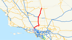
The California State Route 14 (abbreviated CA 14 ) is a state highway in the US state of California , the North-South direction runs in.
The State Route begins on Interstate 5 near Santa Clarita and ends near Inyokern on US Highway 395 . It runs through the Mojave Desert and is therefore known as the High Desert . Together with the US 395, it connects the Greater Los Angeles Area with large places like Reno . While the southern part of the road runs through rural canyons and suburbs, the northern part offers good views of the Sierra Nevada mountain range. Part of the State Route runs through desert-like areas and especially around Mojave through very sparsely populated areas.
On October 13, 2007, there was a serious accident with several dead and injured at the Newhall Pass Interchange with Interstate 5. The accident site was about 30 miles north of downtown Los Angeles, in an approximately 170 m long bypass tunnel for trucks.

swell
- ↑ New York Times: Pileup in California Freeway Tunnel Kills at Least 3, October 14, 2007
See also
Web links
- California @ AA Roads route description with photos
- California Highway