Canim River
| Canim River | ||
|
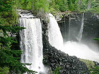
Canim Falls |
||
| Data | ||
| location | British Columbia ( Canada ) | |
| River system | Fraser River | |
| Drain over | Mahood River → Clearwater River → North Thompson River → Thompson River → Fraser River → Pacific | |
| origin |
Canim Lake 51 ° 52 ′ 42 " N , 120 ° 36 ′ 53" W. |
|
| Source height | 772 m | |
| muzzle |
Mahood Lake Coordinates: 51 ° 53 '4 " N , 120 ° 31' 8" W 51 ° 53 '4 " N , 120 ° 31' 8" W. |
|
| Mouth height | 629 m | |
| Height difference | 143 m | |
| Bottom slope | 15 ‰ | |
| length | 9.8 km | |
| Outflow location: 8 km above the mouth |
MQ 1945/1947 1959/1962 |
18 m³ / s |
The Canim River is a river in the central east of the Canadian province of British Columbia .
The Canim River is located in the south of the Quesnel Highlands , about 130 km north of Kamloops . It forms the 9.8 km long drain from Canim Lake to Mahood Lake, which is further east . It cuts through a lava plateau in a ravine. Almost 2 km below Canim Lake are the 25 m high Canim Falls ( ⊙ ) on the river. The river has a height difference of 143 m. The entire course of the river is within Wells Gray Provincial Park .
Web links
Commons : Canim River - collection of images, videos and audio files
