Cap Ferret
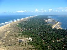
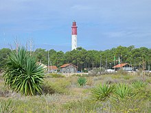
Cap Ferret is a cape and the southernmost point on the spit that separates the Bassin d'Arcachon from the Atlantic Ocean . The peninsula is located in the Gironde department in southwest France . The cape is best known for its lighthouse and is a popular summer destination in the heart of the Landes de Gascogne and the Pays de Buch .
Claouey, Les Jacquets, Petit and Grand Piquey, Piraillan, Le Canon, L'Herbe, La Vigne and Cap Ferret lie on the peninsula from north to south.
geology
The peninsula on which the cape lies has a very short geological history, not even 3000 years in the past. It is one of the youngest stretches of coast in Gascony .
As in the rest of the Landes de Gascogne, the soil is made up of iron-shed sandstone , the origin of which is due to the connection between the quartz grains as a result of the decomposition of the clay by the presence of iron and organic matter. It forms the Ortstein , called Alios . As a result, the water seeping into the groundwater is very heavily saturated with dissolved iron and thus causes visible traces on the bank, a hint of rust.
It is this phenomenon that justified the naming of the headland as "Cap Herré" , which means "iron tip" in the Gascon language . Later it became the current name.
The first residents
In the 19th century, some fishermen had settled in different places on the peninsula, but the headland was only temporarily settled.
The fishermen from La Teste and from Gujan came with pinnaces to catch the fish at the entrance to the basin. They built a few huts on the bank that they could easily reach. Lying behind the tip of the cape, they offered shelter from the harsh westerly winds. In 1857 there were around a dozen of these huts near the lighthouse . In the second half of the 19th century, other groups of people joined them, such as civil servants, customs officers, lighthouse keepers and forest workers.
Under Napoleon III. From 1860 oysters were raised in Gascon. The mudflats were parceled out for this purpose and the parcels were sold. Oyster farming, resin extraction and forestry shaped the landscape, later tourism joined the important economic sectors in the area. The municipality of Lège-Cap-Ferret , located on the peninsula, benefits from both the mudflat landscape of the basin and the vastness of the Côte d'Argent . The Dune du Pilat is located opposite in the middle section of the strait to the Bassin d'Arcachon .
Web links
- Panoramas du cap Ferret french
- Site officiel du cap Ferret french
Coordinates: 44 ° 37 ′ 19 ″ N , 1 ° 14 ′ 59 ″ W.


