Cote d'Argent
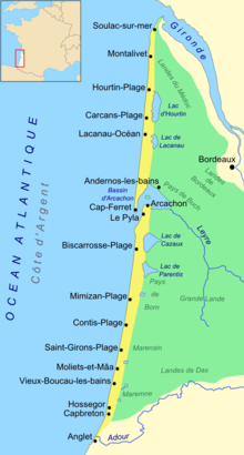
The Côte d'Argent is a coastal strip on the Atlantic Ocean on the Bay of Biscay in southwest France . It stretches from the Gironde in the north to the Adour River in the south.
The name means "Silver Coast". The name comes from the special quality of the sand that occurs there. The Atlantic coast is very rich in mussels and oysters at this point . The abrasion and remains of the shells of these shellfish mixed with the sand over the millennia. As a result, with a certain incidence of light in the evening hours, the sand in the surf glistens like silver dust.
Northern section
Its location on the Medoc peninsula creates the remarkable situation that all waters in the hinterland flow either into the Gironde or into the Bassin d'Arcachon . Since coastal precipitation seeps away through the sand, a practically uninterrupted sandy beach has formed from the headland at the Pointe de Grave to the tip of Cap Ferret - with almost 100 kilometers one of the longest in Europe.
Localities in the northern part of the coast (all in the Gironde department ):
- Le Verdon-sur-Mer
- Soulac-sur-Mer
- Vendays-Montalivet
- Hourtin
- Carcans
- Lacanau
- Le Porge
- Lège-Cap-Ferret
Southern section
To the south of the Arcachon basin, the sandy beach is interrupted by a few smaller rivers - called courants - that flow directly into the sea, the northernmost at Mimizan. At the exit of the basin is the Dune du Pyla , the highest shifting dune in Europe.
Localities in the southern part of the coast:
Gironde
Country
- Biscarrosse
- Mimizan
- Contis
- Lit-et-Mixe
- Vielle-saint-girons
- Moliets-et-Maa
- Messanges
- Vieux-Boucau-les-Bains
- Seignosse
- Soorts-Hossegor
- Capbreton
- Labenne
- Ondres
- Tarnos
Pyrénées-Atlantiques
Coordinates: 44 ° 35 ′ N , 1 ° 15 ′ W

