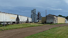
Carrington, North Dakota
| Carrington | ||
|---|---|---|
|
Location in North Dakota
|
||
| Basic data | ||
| Foundation : | 1883 | |
| State : | United States | |
| State : | North Dakota | |
| County : | Foster County | |
| Coordinates : | 47 ° 27 ′ N , 99 ° 7 ′ W | |
| Time zone : | Central ( UTC − 6 / −5 ) | |
| Residents : | 2,268 (as of: 2000) | |
| Population density : | 596.8 inhabitants per km 2 | |
| Area : | 3.8 km 2 (approx. 1 mi 2 ) of which 3.8 km 2 (approx. 1 mi 2 ) are land |
|
| Height : | 484 m | |
| Postal code : | 58421 | |
| FIPS : | 38-12340 | |
| GNIS ID : | 1028287 | |
| Website : | www.carringtonnd.com | |
Carrington is a city in the US state of North Dakota with 2,268 inhabitants. It is the county seat of Foster County .
history
The settlement of the place began in the 1880s and was favored by the construction of a railway line of the Northern Pacific Railway in the year 1882. It was only with this connection to the railway network that goods and building materials, especially wood, came to the region, and originally from Houses and the first shops were built with shelters erected. Carrington has been its administrative seat since the establishment of Foster County in 1883.
Economy and Infrastructure
The economy in Carrington has been predominantly agricultural to this day. At the same time, the place is the headquarters of the Dakota Growers Pasta Company, Inc , a supra-regional manufacturer of pasta products .
US Highway 52 runs through Carrington, and Carrington Municipal Airport is just under 2 kilometers west of the city center . The place houses an elementary school and a high school .
Individual evidence
- ↑ a b History. City of Carrington, accessed September 16, 2009 .
- ^ 46D-Carrington Municipal Airport. www.airnav.com, accessed September 16, 2009 .
Web links
- www.cgtn-nd.com Website of the local chamber of commerce

