
Chūbu Sangaku National Park
|
Chūbu Sangaku National Park
|
||
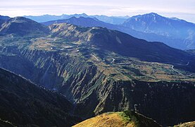
 Tateyama and Tsurugi seen from Mount Nunobiki |
||
| location | Nagano Prefecture / Gifu Prefecture / Toyama Prefecture / Niigata Prefecture , Chūbu , Japan | |
| surface | 1,743.23 km² | |
| WDPA ID | 729 | |
| Geographical location | 36 ° 17 ' N , 137 ° 39' E | |
|
||
| Setup date | 4th December 1934 | |
| administration | Japanese Ministry of Environment | |

The Chūbu Sangaku National Park ( Japanese 中部 山 岳国立 公園 , Chūbu Sangaku Kokuritsu Kōen ) comprises the Hida Mountains (Japanese Northern Alps), a mountain region on the borders of the prefectures Nagano , Gifu , Toyama and Niigata in the Japanese region of Chūbu . As usual, the park is divided into a specially protected zone, a protected zone and an ordinary zone.
Overview
The area was one of the first to be designated a national park in Japan on December 4, 1934 and covers 174,323 hectares. Some of the most famous mountains in Japan are located in the 3000 m range. Due to a geological fault that runs along the eastern side of the Japanese Northern Alps, mountains formed due to the crustal movement, which were then subject to severe erosion. Volcanic activity added to the complexity of the mountain range.
The central area is characterized by many rivers that often flow in steep valleys with a V-cross section, such as the Kurobe River ( 黒 部 川 , -gawa ) to the north, the Azusa River ( 梓 川 , -gawa ) to the south, the Takase -River ( 高 瀬 川 , -gawa ) to the east and the Kamata River ( 鎌 田 川 , -gawa ) to the west.
The park is located in a region with heavy snowfall, so snow in some places remains over the summer. The three most famous snowy gorges are Tsurugi-sawa Daisekkei ( 剣 沢 大雪 渓 ), Hakuba Daisekki ( 白馬 大雪 渓 ) and Harinoki Daisekki ( 針 ノ 木 大雪 渓 ).
Mount Yakedake ( 焼 岳 ), which dammed the Azusa River through an eruption, still shows volcanic activity even today. In the vicinity of Mount Tateyama one can see fumaroles , hot springs ( onsen ) in Jigokudani ( 地獄 谷 ) and lava areas in Midagara.
Individual sights from north to south
- The Tsugaiki Nature Park ( 栂 池 自然 園 , Tsugaiki jizen'en ) is a raised bog at 1900 m with a view of Mount Shirouma.
- The Kurobe Gorge ( 黒 部 峡谷 , Kurobe kyokoku ) is one of Japan's most famous gorges. It is traversed by the Kurobe River, which flows over the Kurobe Dam and other small reservoirs into the Sea of Japan. The lower section of the gorge is accessed by a tourist train (gauge 700 mm). This was originally built between 1923 and 1937 for the construction of a dam above the terminus Keyakidaira ( 欅 平 ; 599 m).
- The mountain Shirouma-dake ( 白 馬岳 ; 2932 m), also read Hakuba-dake, stands above the Hakuba Gorge with eternal ice.
- The Happō-One ( 八方 尾根 ) is a varied mountain area, which is accessed by a study trail.
- The mountain Tsurugi-dake ( 剣 岳 ; 2999 m) is called the "sanctuary of rock and snow". It is difficult to climb despite the many iron chains.
- The mountain Tateyama ( 立 山 ; 3015 m) is one of the "three holy mountains of Japan" ( Nihon sanreizan ).
- The Midagahara plain ( 弥陀 ヶ 原 ), a lava plateau, is characterized by an upland moor that is interspersed with numerous small ponds. Paths laid out on wooden planks help you to cross.
- Mount Yariga-dake ( 槍 ヶ 岳 ; 3180 m) looks a little like the Matterhorn .
- Mount Hotaka-dake ( 穂 高 岳 ) is a collective name for the peaks of Kitahotaka ( 北 穂 高 ), Karasawa ( 涸 沢 ), Okuhotaka ( 奥 穂 高 ) and Maehotake ( 前 穂 高 ), among which the Okuhotaka is the highest mountain in the Northern Alps is.
- Kamikōchi ( 上 高地 ) is a varied area with Lake Taishō ( 大 正 池 , Taishō-ike ), which was created by an eruption of the Yakedake.
- The Norikura highlands ( 乗 鞍 高原 , Norikura kōgen ) consists of the Ichinose grasslands ( 一 の 瀬 園地 , Ichi-no-se enchi ) with many bodies of water and azaleas.
- Norikura-dake ( 乗 鞍 岳 ) is a mountain range with Kengamine ( 剣 ヶ 峰 ; 3026 m) as the highest point.
Flora and fauna
The park offers a lot of untouched nature. The Japanese dwarf pine and flower meadows can be found above 2500 m . Between 1500 and 2500 m are occupied by the Veitchs Tanne and the Maries-Tanne . Beeches and the oak species Quercus crispula ( Mizunara ) can be found below 1500 m .
The animals in the mountains include the Asiatic black bear , Japanese serau (a type of mountain goat), the Japanese macaque , the ermine and birds such as the golden eagle , the crested eagle , the ptarmigan, the jay , the butterfly, the kingfisher .
Others
The mountains of Tateyama, Kasagadake and Yarigadake were worshiped as sacred in the Edo period . In particular, the Tateyama, together with the Fuji and the Haku , belonged to the Three Sacred Mountains of Japan ( Nihon sanreizan ).
During the Meiji period , the English mining engineer William Gowland (1842–1922) is said to have been the first to measure the mountains and coined the name "Japanese Alps". The name was later conveyed to the world by the English missionary Walter Weston (1860–1940), who is honored with a plaque in the park.
photos

Kurobe Gorge

Kurobe Gorge
Eternal ice at an altitude of 400 m
Shirouma-dake
Midagahara

Norikura highlands


literature
- Japanese Ministry of Environment (Ed.): Chubu Sangaku National Park (Japanese, English)
Web links
- Park website (Japanese and English)
- World Database on Protected Areas - Chūbu-Sangaku National Park (English)