Chandpur
|
চাঁদপুর Chandpur |
||
|---|---|---|
|
|
||
| Coordinates | 23 ° 13 '28 " N , 90 ° 38' 58" E | |
| Basic data | ||
| Country | Bangladesh | |
| Chittagong | ||
| District | Chandpur | |
| ISO 3166-2 | BD-09 | |
| surface | 7.8 km² | |
| Residents | 159,021 (2011) | |
| density | 20,466 Ew. / km² | |
|
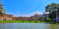
The railing of Chanpur University College
|
||
Chandpur ( Bengali : চাঁদপুর , Cā̃dapur ) is a city in southeastern Bangladesh on the banks of the Meghna River , near its junction with the Padma River . In the city with more than 100,000 inhabitants is the seat of the administration of the district of the same name . The city consists of 15 wards (districts) and extends over an area of 7.77 km².
The city has had its own city council since 1897. During the first half of the 20th century, several Indian and European companies set up jute processing factories in Kumilla . Most of these factories were closed as a result of the partition for the independence of the subcontinent in 1947.
Nevertheless, the port remained an important transshipment point for jute and grain. Furthermore, the port is still used today as a trading center for ship repairs, for salt refineries, for the manufacture of fishing nets and for the production of oils.
Parts of the city are increasingly affected by erosion by the Meghna. Since 1973 the government of Bangladesh has provided over 350 million taka to build the dams .

