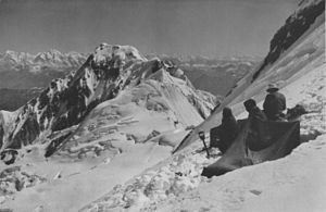
Chongra
| Chongra | ||
|---|---|---|
|
German-American Himalaya Expedition 1932, view of the Chongra |
||
| height | 6830 m | |
| location | Gilgit-Baltistan ( Pakistan ) | |
| Mountains | Nanga Parbat Group ( Western Himalayas ) | |
| Dominance | 7.97 km → Rakhiot Peak (Nanga Parbat) | |
| Notch height | 690 m ↓ ( 6140 m ) | |
| Coordinates | 35 ° 19 '28 " N , 74 ° 40' 27" E | |
|
|
||
| First ascent | June 14, 1932 by Peter Aschenbrenner and Hugo Hamberger | |
The Chongra ( English Chongra Peak ) is a mountain in the West Himalayas in the Pakistani special territory Gilgit-Baltistan .
The 6830 m (according to other sources 6824 m ) high main summit of the Chongra is located 12.4 km northeast of the Nanga Parbat main summit, with which it is connected via its northeast ridge. The Astor river valley runs along its eastern flank, and the Indus valley to the north . The Bulder Glacier runs on the north slope and the Rakhiot Glacier on the southwest slope .
The Chongra was first climbed on June 14, 1932 by Peter Aschenbrenner and Hugo Hamberger as part of the German-American Himalaya Expedition in 1932 . It is unclear whether they actually climbed the main summit and not a lower secondary summit. The main summit was climbed on August 20, 1971 by a Japanese expedition (Masahiko Kaizu, Kiyoshi Hara and Tamiya Takahashi) over Rama Peak . The descent led over the northeast ridge.
In addition to the main summit, the mountain has other peaks: north summit ( 6565 m ), south summit ( 6448 m ), middle summit ( 6455 m ) and west summit ( 6554 m ).
Web links
- Chongra on Peakbagger.com (English)
- Chongra at flickr.com (photo)
- mountainsoftravelphotos.com (photo)
- summitpost.org
- Map of the Nanga Parbat massif at himalaya-info.org

